Dudeman & Daniel Tarr
Cydonia - City on Mars
- An extended review of The Face on Mars -
2009.

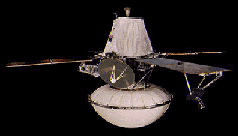
Viking (spacecraft), first space probe to survive landing on the surface of the planet Mars. Launched by the National Aeronautics and Space Administration (NASA), Viking was the most extensive and complex mission ever to explore Mars and included several experiments designed to test for life on Mars. The Viking mission used two identical spacecraft to orbit and land on Mars. NASA launched Viking 1 on August 20, 1975, and Viking 2 on September 9, 1975. Each Viking spacecraft consisted of an orbiter, carrying a variety of imaging and remote sensing instruments to study Mars from orbit, and a lander, designed to operate on and intensively study the planet's surface. It took each spacecraft almost a year to reach Mars-Viking 1 went into orbit around Mars on June 19, 1976, and Viking 2 on August 7, 1976. Viking 1 landed on Mars on July 20, 1976, on the western slope of Chryse Planitia. Viking 2 set down September 3, 1976, at Utopia Planitia, 6460 km (4014 mi) from Viking 1.
The Viking spacecraft continued to function long past their planned 90-day mission. The Viking 2 orbiter ran out of fuel for its attitude-control system (the system that keeps the craft's solar panels pointed at the sun) and shut down on July 25, 1978; Viking's controllers on the earth were able to keep the Viking 1 orbiter functioning until August 7, 1980. The last data from the Viking 2 lander were received on the earth on April 11, 1980, and the Viking 1 lander made its final transmission on November 11, 1982. |
|
The Face on Mars
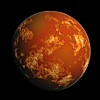
The Cydonia Plateau is home to the famous and controversial "Face on Mars". This mile long, half mile wide and quarter mile high "trick of light and shadow" (NASA) is surrounded by dozens of obviously artificial and mostly pyramid-like structures, all are aligned with the Martian cardinal points and arranged on a proportional grid of one by the square root of two the diagonal of a perfect square and first irrational number.
The entire layout of the complex employs a higher order of mathematics which extrapolates from what was known to the ancients as Sacred Geometry and seems to include the still elusive (to us) Fourth Theorem - a calculus poser involving higher dimensions.
The site also seems to be curiously mirrored (though somewhat reduced in scale, at 14:1) in Avebury (just 30 km north of Stonehenge) with many interesting lignments, among them: When the Spiral Mound on Mars is aligned perfectly with Silbury Hill itself (both are logarithmic spirals), the large crater lines up exactly to The Outer Circle and a road (which predates the area's known history) corresponds perfectly to "the wall" part of "the 10" and southwest, the peak of the five-sided DM Pyramid corresponds to the The Stele.
|
3D Extrapolation of Cydonia
(image by Mark J Carlotto, PhD) |
 |  |  |  | Extraplanetary Archaeology - authorities are quick to
dismiss perhaps the most important scientific discovery
in Human history: literal mountains of irrefutable scientific
data, showing that an intelligent, technically sophisticated
and humanoid culture must have once existed on Mars. | | |
|
There is a face on Mars. A huge stone, human face: about a mile long, a half mile wide and a quarter mile high. If you believe this, people will laugh at you. But, perhaps the universe is arranged so that something like this is not surprising. If aliens exist, if they've been here, watching us, for millennia, even eons; if Atlantis is real; if the gods of our ancient texts were visitors from other worlds; if humans from planet Earth, or humanoids from other worlds, were exploring this system in ancient times - it takes something like that for something like this to make perfect sense. If, having vaguely heard of all of these (and other silly stories), and taken them less than seriously (as you're supposed to), you are suddenly struck with this image, presented with the implications: that all that you hold dear, all of the commonly held, society sanctioned beliefs about Man's place in the Universe, and what may or may not be out there - all of this seems suddenly naive, and this frightens you (understandable, it's a bit of a drop). Then, laughter is your only recourse (also sanctioned by society). If you wish to not believe, do not read any further.
There are also pyramids on Mars. At 41° north latitude of our second nearest planetary neighbor, there is an area we modern Earthlings call Cydonia, where exists an elaborate complex of massive and obviously artificial structures - everything about them based on something the ancients called Sacred Geometry.
There's literally mountains of scientific data to back this up; but NASA, government officials, professional skeptics and "mainstream scientists" will (sometimes between flamboyant fits of sensationalism), tell the masses, through the media, how laughably dangerous it is to jump to conclusions about something so mind-bogglingly incredulous as that; and other things which everybody knows are true, and how ridiculous that may just happen to sound. Just thinking along those lines is sadly disrespectful to science, itself.
But make no mistake: there is incontrovertible evidence for the artificiality of the Cydonian structures, long predating any known civilization - on Earth, or anywhere else.
|
The first questions on everyone's mind, are of course,
wondering who could possibly have built them - no one knows.
If it is the face of a man, or some other humanoid (two eyes, a nose and a mouth),
he appears to be wearing a helmet - prehaps even reminiscent of ancient Egyptian headwear.
Now we're getting into Ancient Astronaut territory - stop right there, or you're a silly kook.
Closer inspection discerns a mouthpiece, gleans a breather - the air is thin on Mars, you know.
Aha - they did it - they made it work, despite improbable obstacles and impossible conditions,
they built a thriving city of pyramids with Sacred Geometry on the shores of a Martain sea
- and then their planet was smashed with an asteroid.
Perhaps their detractors were insulted. Imputence.
The Sphinx, it turns out, dates back to 10,500 BC (the Age of Leo), right before a minor global cataclysm here on Earth; which is not unlikely to happen, should a major global cataclysm occur on Mars. The Pyramid Complex at Giza is also based on Sacred Geometry, as are many other ancient "sacred" sites worldwide - all of them arranged geometrically to each other on the globe, using the same simple format of basic universal numbers. A search is underway for other artificial sites on Mars - and, using this simple logic, once another is found,
we have a pretty good idea where to look for many more.
If you wonder why no one seems to be taking this seriously, that's just the way things are.
The way of the world today, at this level in our intellectual and social development,
supposedly every foundation of our society would be challenged
- our entire way of life: from science and technology to economics, politics and religion.
This is huge. This changes everything.
Everybody you know will suddenly purport to have believed in UFOs all along.
(It's just not polite conversation.)
Millions may be found cowering under their beds in the fetal position.
And, for millions more, time for war.
We're not ready yet.
All of the history books would have to be rewritten.
"The way things are" would suddenly change overnight.
Slowly at first, more in shock than anything else;
but soon, certain chaos; definite disaster
- and there would be no turning back
- or, so goes the reasoning.
Imagine religious institutions' positions, if there were irrefutable evidence that Man was not created on Earth - many would probably insist they still don't believe it; or, that it is the work of the devil. Imagine every nation on Earth, and uncountable internal factions, clamoring for control of every archaeological site they could guess at or half imagine, (or fake: having now become the ultimate commodities, themselves). Governments take over, but they're not equipped to - even military dictatorships will find it impossible to police every ancient monument. And, finally (for some), whoever is able to, will begin seriously searching for Atlantis; trying to find something of the lost rumored super technology - that could, as a species, snap us out of our long amnesia
- but it could also snap us, into many pieces. |
|
Those in power seldom have it in their interest to share it. But they also don't want everything to fall apart, either. Perhaps this is the most important reason why those currently in power so openly and casually dismiss any piece of evidence even remotely along these lines. The first order of business: dismiss any and all facts in evidence; to the point of ridicule, if need be - and next, perhaps even more importantly: discredit the messenger. They don't want anyone else to learn the truth - not just yet anyways: not until they have complete control over the situation.
And why stop there?
NASA's official position is that "most scientists" think that the images are an optical illusion - that's what they say.
Or, a perhaps wider perception is, that most scientists are afraid to bring forth findings that challenge the establishment - they'd be ruined.
The established timeline is dubious, and fulfilled a political need in past centuries
for Science to have an easily comprehended answer to many burning questions
- but conclusionf for which there was no real hard evidence supporting.
If you're a scientist, and you don't believe in evolution,
you can't also believe that we're alone in the universe
- not and call yourself a scientist; it just doesn't make sense.
These conclusions conveniently followed very closely to matters historic and existential,
found in western translations of the Bible, and thus were generally accepted as fact without question.
It's not just evolution, it's everything.
|
On August 6, 1996 NASA announced Mars Rock ALH84001 (collected from the Alan Hills region of Antarctica, in 1984) was found to have what appears to be fossilized bacteria from millions or perhaps billions of years ago.
|
It is surprising however, that despite the many technological advances in the past century, very few of these suppositions have been openly challenged - despite their now glaring inaccuracies. Debates rage for months, years, even decades - reputations and careers are destroyed - knowledge rots. Gamma-ray bursts turned out to be super-massive black-holes; dark matter, the interstellar medium; Io has volcanoes. When finally an innocent piece of evidence is happened upon, scientists sometimes don't know what to make of it, at first. Too often, the only acceptable conclusion, is that it can't possibly be simply, exactly what it seems. It can't be the obvious first thing you think of, which we were taught to laugh at in school. But then, one rogue comes along, perhaps with the job security to point out the obvious - and everyone's happy again, almost; for a time. For probably every stunning scientific discovery, there's a discredited scientist somewhere, who submitted a paper ages ago, hypothesizing same; and was deemed misguided - a kook.
In the scope of history, Science seems to be making an incremental ascension to the truth, as each new revelation eventually becomes politically convenient. In the Renaissance, Galileo's telescope ultimately helped prove earlier "heretic" theories that the Earth orbits the Sun, and not the other way around. The People of the day were ready for this, but the Church was not - neither was the Church ready for the People to know the Truth. After all, if they were seen to have been so wrong for so long about something like that, everything else may have come into question - but, most importantly, their authority. Today, Earth is being gradually downgraded: slowly accepted as being no longer unique in its ability to support life - but these are still grudging admissions. Every day, the scientist who stands firm in his belief of life on other worlds, becomes more and more accepted by his colleagues in more mainstream science - but there is still a long way to go. Yes, Virginia: the Face on Mars, too.
Among the most intriguing and most ridiculed of curiosities supporting the artificiality of the Cydonia Complex is that all of these objects are precisely arranged using the same universal mathematics and Sacred Geometry that are found in all of the most impressive and most ancient of archaeological sites here on Earth - where there also just happen to be giant pyramids, occasionally; another sacred geometrical form - but nothing even approaching the scale and scope of those found on Mars.
Today, thanks to the Mars Rock ALH84001 and recent robotic missions, it is widely accepted that there was once water, and even a breathable atmosphere on Mars. But whatever global cataclysm that made the Red Planet now completely inhospitable to Human life, these massive monuments remain in stony testimony to a once thriving perhaps even Human civilization, present on Mars so long ago - who were apparently far more technologically advanced than we are today - unless they were just poets at math, and shuttled interplanetarily by someone else. Possibly Earthlings: maybe humanoid life originated on Mars first, and we're its descendants. This is not science fiction. This is science fact.
It may take the world a while to warm up to the idea. |
Whoever it is up there, depicted for everlasting posterity, it was designed to be appreciated from above - and at a mile and a half across, over half a mile wide and a quarter mile high - one wonders if the denizens of this ancient coastal region ever considered themselves a planetbound society. Were they visitors, colonists from another star system; or is this just the only remnant we have of an ancient humanoid civilization on Mars?
Maybe it was pure artistic expression, or even simple vanity,
like the kind of statues we have virtually everywhere in our own modern cities today.
One thing is certain, it stands out like a sore thumb - you can't miss the site.
Intentional or not, meant for themselves or distant descendants (namely, us):
this is exactly what one would expect to find if our society were to hold the belief
that there has ever been beings like ourselves beyond our sphere.
In any case, even if there were no Face, the design and layout of the complex surrounding:
this is the trademark mysterious way that the ancients did things
- yet, "mainstream" science appears to be refusing to even look into it.
As far as they're concerned, there is nothing to it;
and anyone who thinks there is, should not be taken seriously.
But some researchers have discovered that authorities are in fact taking this very seriously, indeed.
But it's a members-only club; and those who would speak this shocking truth aloud,
for anyone to hear, need not apply themselves.
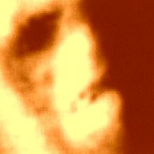
High-resolution images of the Face, made from NASA's original 1998 MGS widely publicized "debunking" press-release image (below); which is suspected to have been altered in favor of ambiguity. The lighting is from the east (morning sun), perhaps naturally obscuring detail: of obvious, evident, equidistant, parallel, artificial symmetry in the surrounding platform; especially in the straight eastern and curved north edges. But, even the "raw" image clearly shows the straight western and curverd southern edges: so the public can see where even a conscientious scientist might easily make the mistake. |
| | | Mars orange false-color
added here for contrast | same image inverted to simulate
lighting from the northwest | rotated 180° (upside down)
reminding us of its symmetry |
|
The Viking Photos
The Overlooked Images
In 1976, Viking 1 was the much anticipated next logical step after the
Mercury and Apollo missions.
On this groundbreaking survey, the primitive probe/spacecraft took many
thousands of pictures red planet's features and sent them back to NASA.
On July 25th, Tobias Owen of JPL was going over the data from Viking 1,
for possible landing sites for Viking 2, when he came across a glimpse
of history.
"Oh my god, look at this! That looks like a face!" he said, as he
examined frame 35A72 (below),
a solitary structure reminiscent of the Sphinx, staring serenely out
into space.
In a press conference later that same day, Viking project spokesman
Gerry Soffen coined the famous phrase "trick of light and shadow"
- and claimed that just a few hours later, the image no longer appeared
to be a face
- casually dismissing perhaps one of the greatest discoveries of all
time.
This was, in fact, a lie - there were no pictures taken of Cydonia a
few hours later, as night had fallen on that side of the rusty planet.
Any "later" photograph proving that the mound in no way resembled a
human face was not to be forthcoming
- and if any other Cydonian images were ever shot, the matter was not
discussed openly.
There were to be no further images released to the public until Mars
Global Surveyor - on May 5, 1998.
|
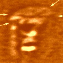
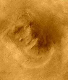
JPL Press release on The Face on Mars - July 31, 1976 - from Viking 1 frame 35A72 |
JPL Press release on The Face on Mars - July 31, 1976 "This picture is one of many taken in the northern latitudes of Mars by the Viking 1 orbiter in search of a landing site for Viking 2. The picture shows eroded mesa-like landforms. The huge rock formation in the center, which resembles a human head, is formed by shadows giving the illusions of eyes, nose, and a mouth. The feature is 1.5 kilometers (1 mile) across, with the sun angle at approximately 20 degrees. The speckeld appearance of the image is due to bit errors, emphasized by enlargement of the photo. The picture was taken on July 25 from a range of 1,873 kilometers (1,162 miles). Viking 2 will arrive in Mars orbit next Saturday [August 7] with a landing scheduled for early September. "
In the above caption, replace the possibly intentionally misleading NASA words "shadows" with "fissures" or "indentations" - and "illusions" with "appearance." Cydonia investigators believe that this press release was censored at the last minute and that the original statement reflected the scientists true feelings of astonishment and cautious celebration, regarding the surprising discovery on the first close-up photos of Mars. Imagine how many more telling sentences might have been omitted from this announcement regarding the first images from another planet, that just happen to reveal not one, but several, possibly man made monuments - and suddenly the whole Cydonian issue is taken more seriously. |
From: The Case for the Face - by McDaniel, Paxon, et al - p. 69
The next development was a decision from NASA
that Viking 2 would not, after all, land at Cydonia.
Apparently the site was now deemed
"unsafe." According to Carl Sagan:
44 degrees north was completely inaccessible to radar site-certification; we had to accept a significant risk of failure with Viking 2 if it was committed to high northern latitudes. . . . To improve the Viking options, additional landing sites, geologically very different from Chryse and Cydonia, were selected in the radar-certified region near 4 degrees south latitude.
All this notwithstanding, it is an extraordinary fact that Viking 2 was finally set down at a latitude even higher than Cydonia. It landed - and was almost overturned by boulders - on the distinctly unpromising rock-strewn plain called Utopia, at 47.7 degrees north latitude, on 3 September 1976. Thus - for no obvious reason says James Hurtak - "a multimillion dollar effort may have overlooked 'paydirt' and may have become a trivial event. . . . A poor selective factor had been used to choose an area of minor geological and biological significance. It was like choosing the Sahara Desert as a suitable landing site on
our own planet."
|
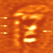
Cydonia - Viking 1 frame 35A72 |
|
NASA Viking 1 Frame 35A72 - from the 1979 German book Wir, vom Mars by Walter Hain
The many dots in the image above is "salt and pepper" or "bit errors" or missing-data static
Viking 1 Landing Site
Viking 1 landed at Chryse Planitia on July 20, 1976
just north of Valles Marineris |
Spin Control The whole issue of Cydonia as a possible landing site was dropped as soon as the pictures became public. This is quite surprising considering that it was a far better and more interesting candidate than Utopia (where Viking 2 ultimately landed), According to Carl Sagan: "there was a significant chance of small quantities of liquid water there." There can be only one reason for the sudden dismissal: they didn't want anyone to know about the strange monuments found there. Any proof of anything beyond what is considered to be accepted human history would be controversial in the extreme. But is it possible that Cydonia was not left alone, but actually highly classified at the highest levels? And what could already seem more ridiculous, more easily dismissed, by serious "respectable" science? To quote the movie Contact, ironically written by Carl Sagan, "first rule of government spending: why have only one, when you can have two at twice the price?" How many missions could there possibly be that the public at large knows nothing about? And how many of the supposedly malfunctioned spacecraft, are actually alive and well? The only way that "we the people" would have gotten anything anywhere near full disclosure from the Mars missions would have been if all of NASA's wildest hopes and dreams had come amazingly true - that Mars was, as previous data had suggested, capable of supporting life as we understood it in the 1960s and 70s. If Mars had moss or algae, or even insects - big business would have been instantly involved and there would certainly be people there by now. Imagine, another tiny island to be conquered - completely isolated from outside interference and no pesky indeginous inhabitants to lay claim to the wealth of resources to be found on an entire planet - not to mention the strategic military and political values. Perhaps science and civilization have been given a back seat to these interests. Ever since man began sending missions to Mars, nearly all of them have mysteriously failed. It seems that if they manage to make it into space at all, they break down somehow, or all contact is lost, or they crash onto the surface of the planet, never to be heard from again - sometimes under such mysterious circumstances as to raise the eyebrows of ufologists. One perhaps intentional effect of all this staggering disappointment is that the public at large, though perhaps at first intensely curious about the red planet, ultimately has no idea of the controversial reality. Many suspect that this was far too convenient to be true, as it only served to decrease attention and increase the distance between the public and that arm of the space program - and if there really are monuments on Mars, the powers that be have no intention of sharing that information with the general public. It is also especially highly likely that what can be found out on the subject is only the smallest fraction and most easily dismissable aspect of the entire story. Who knows - perhaps, as ufologists suggest, there really is sentient life on Mars, occasionally shooting down whatever probes of ours they
can. |
Mars Global Surveyor - Mars Orbiter Camera
Malin Space Science Systems and the California Institute of Technology built the MOC using spare hardware from the Mars Observer mission. MSSS operates the camera from its facilities in San Diego, CA. The Jet Propulsion Laboratory's Mars Surveyor Operations Project operates the Mars Global Surveyor spacecraft with its industrial partner, Lockheed Martin Astronautics, from facilities in Pasadena, CA and Denver, CO.
An attempt to take a picture of a portion of the "Face" itself (M12-01787) in mid-February 2000 was foiled when the MGS spacecraft experienced a sequencing error and most of that day's data were not returned to Earth. Only the first 97 lines of M12-01787 were received....
The MGS spacecraft had a sequencing error on February 17, 2000, which resulted in a loss of most of the data collected by the spacecraft's instruments that day. The anomaly is described below in the MGS Status Report from the Jet Propulsion Laboratory. Status reports from MGS are generated weekly and can be found at » NASA Marsweb.
Here is the content of the MGS Status Report that described the February 17, 2000, events:
Wednesday, February 23, 2000
(DOY 047/19:00:00 to DOY 0454/19:00:00 UTC)
Launch - Nov 7, 1996
Days since Launch - 1206 days
Start of Mapping - April 1, 1999
Days since Start of Mapping - 328 days
Total Orbits = 5987
Total Mapping Orbits = 4305
Recent Events:
The pace of the new mapping Beta sequence generation problem, a build every week, and a realization of new operational constraints imposed by the new mapping scheme, has caused two sequencing errors over the last week.
On 00-048 (2/17/2000) at about 00:00 UTC, the new Beta Supplement sequence, mm014b, was scheduled to kickoff but never went active. Since that new sequence controls the tracking of the HGA to Earth, no downlink was possible. Using a 34-m HEF station, a command was successfully uplinked via LGR-2 to change the uplink rate from 125 bps to 7.8 bps. Then, at 7.8 bps, a mini-sequence was successfully radiated to auto-track the HGA for about 30 minutes per orbit for 4 consecutive orbits, allowing for a 4K real-time downlink. During the first of these orbits, spacecraft telemetry was obtained which showed that MGS was in a healthy condition. During the second of these orbits, the uplink rate was changed back to 125 bps and the new mm014c sequence was uplinked to resume normal operations. The mm014c sequence began execution nominally at 14:20 UTC and has successfully completed execution. The mm015 sequence, was uplinked and began execution on 00-051 (2/20/2000) at 00:00 UTC. The mm015 sequence is scheduled to run through 00-054 (2/23/2000). The net effect of the anomaly was the loss of most of DOY 48 recorded science telemetry.
The cause of the mm014 sequence anomaly was that it was loaded into the incorrect area of the sequence buffer, which was already executing the mm013 sequence. This error was induced by having to split the 7 day beta supplement sequence into two parts due to the size of the sequence and the much reduced uplink time available each orbit due to the complex HGA management. This splitting process introduced an ambiguity in the naming convention: mm013a was used for Part 1 of sequence 013 rather than revision level a, and mm013b was used for Part 2 of sequence 013 rather than revision level b. When a second revision of Part 1 was required, mm013c was used, since mm013b was already taken by Part 2. Due to the ambiguity in the naming convention, mm014 was run through SEQTRAN using the FINCON file from mm013c (Part 1) rather than mm013b (Part 2). The result was that mm014b was loaded into the same buffer area as Part 2 of the previous sequence. Since this previous sequence was still executing when mm014b was uplinked, the new sequence did not go active.
To confound matters, due to the current MGS to Earth range, we are not able to support two-way data (uplink and downlink data) at the high rate 40 ksps real-time downlink rate. Therefore all uplinks are currently performed during orbits in which the recorded data from the previous day is being played back. Therefore confirmation of a successful sequence uplink and activation requires waiting until the next day's data is played back. For this case there was insufficient time available to determine that the sequence load had been rejected and to rebuild a replacement sequence in time. This was due in part to a half-day loss in the schedule due to a problem with our spacecraft test lab (STL).
The second anomaly occurred with the development of the mm016a sequence, which was uplinked successfully to the spacecraft on 00-052 (2/21/200) and scheduled to begin execution on 00-055 (2/24/00) at 00:00 UTC. In this event an error in the recording and playback of the science data was discovered after the sequence had been uplinked. The sequence was successfully terminated on 00-054 (2/23/2000) at ~14:00 UTC and a replacement sequence, mm016b, uplinked several orbits afterwards upon confirmation of the termination of mm016a. The root cause for this anomaly was simply a rush to uplink the sequence early enough to verify its activation in order to avoid a repeat of the mm014 sequence anomaly.
Several changes have been made to the sequence development process for the weekly sequence builds. The first change, which was already going to be made for the next sequence anyhow, was to rename the sequences. The split of the weekly sequences into two parts creates two sequences, mm016 and mm017, for example, rather than mm016a and mm016b. The second and probably the most important change made was to increase the sequence development time by three days to provide sufficient time with margin for development, review, STL validation, uplink and verification of the sequences.
One final note, the failure to get a new sequence on-board the spacecraft poses no risk to the health of the spacecraft. The spacecraft will maintain mapping nadir pointing and articulation of the solar array. Communications from the spacecraft and collection of science data will be interrupted until a new sequence can be uplinked.
Spacecraft Health:
All subsystems are reporting nominal health. A sixth PDS reset occurred on 00-019. So far no cause has been found for the recurring resets. The resets appear to have minimal if any impacts to the instruments. We continue to forward all reset data to the PDS software experts at JPL.
Uplinks:
There have been 14 uplinks to the spacecraft during the last week, including new star catalogs and ephemeris files, instrument command loads, and the mm014, mm015 and mm016 sequences. Total command files radiated to the spacecraft since launch is 4459.
Upcoming Events:
The first fixed-HGA mapping sequence of the beta supplement era is scheduled for March 6 and development of this sequence has begun. One of the limitations of the mapping beta supplement scheme is a loss of South Pole radio science atmospheric data due to HGA gimbal constraints. The project approved a three to four day period each month to perform fixed-HGA operations, in which the HGA is pointed along the spacecraft +X axis and the spacecraft is moved to point the HGA to Earth for an eight-hour period (i.e. four orbits). During the eight-hour Earth pointed period the science data recorded from the previous 24 hours of nadir pointed mapping is played back. This scheme allow radio science observations to be made at Earth occultation ingress and egress, at the expense of collecting mapping data for the eight-hour Earth pointed period. The project also approved monthly MOLA nadir off-pointed polar observations. These observations will be performed during the 24 hour nadir pointing period prior to the first eight-hour fixed-HGA Earth pointed period.
Mars Surveyor Operations Program - Mars Global Surveyor
Cydonia: Two Years Later
MGS MOC Release No. MOC2-222, 5 April 2000
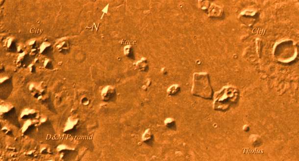
FIGURE 1: Viking Orbiter mosaic showing landforms in Cydonia with popular, informal names.
The recent motion picture, "Mission to Mars," takes as part of its premise that certain features in the Cydonia region of Mars were constructed as monuments by ancient Martians. This idea - widely popularized in books, magazines, tabloids and other news/infotainment media - has its origin in the chance observation (in 1976) by one of the Viking Orbiter spacecraft of a » face-like hill. The "face" and other nearby landforms are labeled in the above mosaic of Viking Orbiter images from the 1970s.
On April 5, 1998, the Mars Global Surveyor (MGS) spacecraft performed a specially-planned maneuver to photograph the "Face on Mars." Having successfully » imaged the "Face" on its first attempt, two additional maneuvers were used to observe other purported "artifical" features: » the "City" (a cluster of small mountains west-southwest of the "Face") and » the "City Square" (a group of four small hills surrounded by the larger mountains of the "City"). These special observations occurred during the Science Phasing Orbits period of the MGS mission, while the spacecraft was in a 12 hour, elliptical orbit. A year later, in March 1999, MGS attained its final, circular, polar Mapping Orbit, from which it has now subsequently observed the planet for a year. During this year of mapping, the Mars Orbiter Camera (MOC) has continued to make observations within the Cydonia region whenever the MGS spacecraft has flown over that area.
Narrow Angle Camera Views of Cydonia
FIGURE 2: Location of MOC images acquired during the past two years, April 1998 to April 2000. Click on ID numbers to browse
the images. These are presented at 40% size with north approximately "up". For full-resolution images, see list below.
The above figure shows the location of all high resolution (narrow angle) MOC images of the Cydonia region that have been obtained to date, including the first three taken in 1998. Images acquired during the Science Phasing Orbit period of 1998 slant from bottom left to top right; Mapping Phase images (from 1999 and 2000) slant from lower right to upper left. Owing to the nature of the orbit, and in particular to the limitations on controlling the location of the orbit, the longitudinal distribution of images (left/right in the images above) is distinctly non-uniform. An attempt to take a picture of a portion of the "Face" itself (M12-01787) in mid-February 2000 was foiled when the MGS spacecraft experienced a » sequencing error and most of that day's data were not returned to Earth. Only the first 97 lines of M12-01787 were received; the image's planned footprint is shown as a dashed box.
Wide Angle Camera Views of Cydonia
Although the resolution of the MOC wide angle cameras is too low to tell much about the geomorphology of the Cydonia region, the images from the red and blue wide angle cameras provide us with two types of information that is of interest in their own right: color and stereoscopic data. Above are a color view and a stereoscopic anaglyph rendition of Geodesy Campaign images acquired by MGS MOC in May 1999. To view the stereo image, you need red/blue "3-d" glasses.
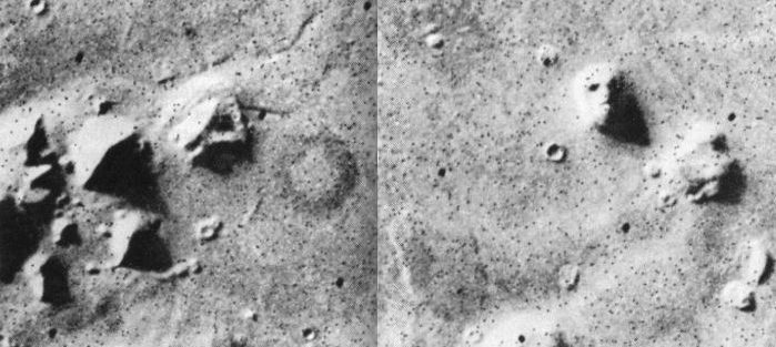
Many apparently artificial, geometrical features are evident in the lower, southern half of the wider angle image (above left). Starting in the middle (just south of The City, and what might have been a natural bay developed into a harbor): a 120° angle, straight edged dropoff and a rougher but mirrored rise to the south, form a parallelogram mesa, approximately 10 miles wide, edge to edge, that was perhaps once a Waterfront Plaza (just west of what appears to be a new crater). And, southwest of that, an almost tetraheydral looking feature that could possibly be an additional pyramidial strusture (compare to the D&M Pyramid, lower center, right image). In the lower quarter, two parallel slash marks, over a mile apart (like an equals sign) forming a kind of avenue between them; each about three miles long and a quarter to half-mile wide. Just below that, a very natural looking bay, with an inlet off to the east; and, to the south of that, very natural looking "foothills" with assorted curious straight-edged and slightly rounded features
which may prove to be artificial upon further analysis.
Additional Information and Views
40% Views Accessed Via Figure 2:
Each of the high resolution, or narrow angle, views of the Cydonia region that can be accessed by clicking on the ID numbers in Figure 2 has been processed to remove the vertical striping that is caused by the non-uniform sensitivity of the MOC narrow angle camera; rotated so that north is approximately "up" and east is toward the right; linearly-stretched to show details/contrast, and reduced to 40% of its original size so that it can be viewed with most web-browsing software. Non-unity aspect ratios have not been corrected in these views.
Full-Resolution Views Accessed by ID Numbers Below:
The full-resolution views of each Cydonia image are provided in the list below. Each has been processed to remove the vertical striping that is caused by the non-uniform sensitivity of the MOC narrow angle camera. No additional processing has been applied. In particular, these images are usually not oriented with north to the top. Many also have aspect ratios greater than 1 (this means that craters will look "squished"). For those who want detailed information on these images that can be used to process them further, an » ancillary data table is provided. Some of the full-resolution images are too large to be viewed in your web-browser; the "save this link as" option should be used to download the image to your desktop, then open it with your favorite image viewing or image processing software. All pictures are in GIF format.
Several Large views of Figure 2 without labels:
All Images Please Credit: NASA/JPL/Malin Space Science Systems
The Investigation of Cydonia
|
|
|
|
Viking 1 took the first main images of
Cydonia - 35A72 and 70A13 in 1976. |
|
|
|
The picture on the left is from frame 35A72. It has been digitally restored with minimal contrast alteration. The picture on the right is from frame 70A13. This image more clearly shows the right shadowed side of the face. Of particular interest are crossed lines in the forehead area and fine structure in the mouth that look like teeth. Since they are in both images and are not aligned with the scan lines it is likely that they correspond to real features on the Face that are near or slightly below the resolution limit of the sensor.
The famous Face on Mars, as received by NASA, in the original 1976 Viking images 35A72 (left) and 70A13 (right) with the originals (top), restored by Mark J. Carlotto - and our corresponding false-colorized versions (bottom) as it is easier for the human eye to discern monochromatic details in shades of red, rather than shades of gray
35A72 was the original image, that made a brief, light-hearted media-ripple on the day the image was received
and rediscovered years later by Goddard Spaceflight Center engineers Vincent DiPietro and Gregory Molenaar
70A13, the "later image" that showed the Face to be "just a trick of light and shadow," shows even more detail
the sun being at about a 20° higher angle, taken a little over an hour earlier in the afternoon. on a later day
from: "Face and Nearby Objects on Mars" by Mark J. Carlotto, Ph. D. |
Light and Shadow
On July 25, 1976, when the frame 35A72, the original image of the Face on Mars, was discovered by Viking engineers, their hearts stopped. After they collected themselves, like most of us would, they made sure it was to be the first order of the day, (even if it turns out to be an optical illusion, this is something very interesting and one of the things that we scientists plan to be spending a lot of time and effort on). Thus, much like Roswell, some thirty years earlier, the press got wind of it before officials could stop it.
This isn't some copy boy with too much coffee in him. These are the guys who you would ask to verify such things. It was their job to analyze the images for NASA - and they were the most qualified in their field. They developed the technology to determine if this was real; and in their opinioin, it was. A photo already having been released, along with the expected speculation, JPL then made a somewhat successful last ditch attempt at spin control:
"The picture shows eroded mesa-like landforms. The huge rock formation ... which resembles a human head, is formed by shadows giving the illusions of eyes, nose, and a mouth."
As if it never entered their minds for a minute that the objects in question could possibly be artificial, an official spokesman for JPL also said in a press conference that day, that a "later image" of the site showed the formation to be merely "a trick of light and shadow" - and the story ended up being no more than somewhat interesting fluff, a lighter sidebar to contrast the "hard science" in NASA's latest triumph, and only a slight distraction away from all the hard data received by Man's first mission to Mars. But, as it turns out, The Face is real. |
Viking image 70A13
artificially colorized orange for contrast to better make out details |
New Attention
Only a small number of the Viking aerial images were decoded from the raw data into pictures - and even fewer were made public. The rest were supposedly filed away for future reference, and mostly forgotten about - until 1977, a year after the image was received, when frame 35A72 was rediscovered by two engineers at the Goddard Spaceflight Center, Vincent DiPietro (below left) and Gregory Molenaar. Until that very moment, these gentlemen were considered highly esteemed NASA scientists, and are today among the main figureheads in the serious, if rogue, scientific investigation of the Cydonia complex. They had not heard the story of the Face on Mars - practically no one had, or it had been long forgotten. But they were under the impression that they would be taken seriously, if their methods were sound, no matter what their conclusions. Besides, it seemed somewhat important. They were in for the ride of their lives.
After becoming somewhat educated in the saga that was Cydonia, and sometimes first hand, a search for any supposedly more revealing photos proved fruitless. But they did discover another perhaps more interesting snapshot of the region, frame 70A13 (above), the only other known Viking image of the Face on Mars. It was taken roughly 35 orbits after 35A72, at a higher sun angle, and shows even more convincing details of the Face.
|
In 1979, lacking any further evidence one way or another, as high resolutions of the surface were another two decades off, Vincent DiPietro and Molenaar - specialists in the fields of computer image analysis on contract to NASA - working on their own, and in secret, developed the Starburst Pixel Interleaving Technique (or SPIT, for short, as in "spitting image"). The image of the face from the Viking frame was a mere 64 pixels square. Basically what they did was divide each pixel into nine subsections, and program their computer to glean the true shade from the data collected about its neighbors. They put both images "through the spitter." What they found was not that the appearance of a face was a chance coincidence or optical illusion, but that it looked even more like a face, bringing out even more startling details. Even this new evidence was scoffed or ignored by their superiors and colleagues at NASA. It seemed like no matter what proof they came up with, the science was falling on deaf ears.
|
In 1980, after three long years of futility and frustration through proper NASA channels, they took their message to the people and published their findings in their book "Unusual Mars Surface Features" with physicist John Brandenburg - and later presented their work at the 156th meeting of the American Astronomical Society. Going public brought the seriousness of the issue to the attention of many potential allies in the struggle for truth - among them, science writer Richard Hoagland, at the first Case for Mars Conference in July of 1981, who was himself present at the original output of NASA disinformation on the Viking 1 face frame in 1976. Hoagland, after viewing further image enhancements of the region, two years later in 1983, would go on to discover other interesting features, dubbed "The City" and "The Fortress" - which are now considered to be among the more important monuments in the immediate vicinity of The Face. He also determined that the City, Face and Cliff appear to be aligned with the Martian summer solstice of Cydonia several hundred thousand years ago!
In the fall [of 1984], a meeting takes place between Rautenberg [an early Mars research project supporter], Sagan, international space policy consultant David Webb, and Louis Friedman, Executive Director of the Planetary Society. Friedman, shown images of the Face, is reported to have covered his eyes and refused to look. In an aside, Sagan confides to Webb, "These are very interesting, but if anyone asks me I will deny that the meeting took place."
....At the National Academy of Sciences meeting in Washington DC in January [of 1985], Sagan discusses the Mars anomalies with Hoagland. Sagan makes an offer to review the material on the subject that Hoagland will send him, and finishes by saying perhaps they will be "exchanging papers in the literature."
Instead of "papers in the literature," a series of newspaper articles critical of the Independent Mars Investigation are published during the spring. The University of California withdraws its sponsorship of Mars Investigation Group formed by Rautenberg. On June 2, a popularized article by Carl Sagan entitled "The Man in the Moon" is published in Parade Magazine. The article includes a version of Viking frame 70A13 which has been colorized in a manner that obscures the crucial shadows. Sagan identifies this image as showing that the "Face" is actually just an ordinary hill. He is harshly critical of the investigators, putting them in the same category as "flying saucer zealots," but mentioning none of them by name.
At the Washington DC "Steps to Mars" conference in mid July, interviews with Sagan and others indicate a growing resistance in the planetary science community toward investigation of the Mars anomalies.
.... [In 1993] Don Ecker, the director of research for UFO Magazine, locates a report on the peaceful uses of outer space, developed for NASA by the Brookings Institution in 1960. The report includes the suggestion that scientists may consider suppressing the discovery of extraterrestrial life or artifacts in order to avoid hypothetical public unrest. [ From: The Case for the Face - by McDaniel, Paxon, et al - p. 283-286 ]
|
Official groups were formed to look into the matter further, such as the Independent Mars Investigation, the IMI - and MIG, the Mars
Investigation Group - but wherever possible, funding was eventually cut due to the controversial nature of their findings and their general refusal to let the issue be quietly swept under the rug. Many of the individuals involved have suffered serious personal, professional, and even physical hardships because of their interest in these strange geographical anomalies, obviously artificial in nature, on the surface of another planet - the ramifications of which would completely rewrite history, and call into question much of what we consider to be status quo, not the least of which being: the dismissal of scientific evidence, and the people who discover them, based on mere political convenience.
Since then, many more learned individuals from all relevant realms of science have dared to investigate what little information there is available about the site, and concluded that Cydonia merits at least further study. In their research, they came across scores of colleagues who were making many interesting discoveries along the same lines. Among the few who are not afraid to release their findings because of the seriousness of their implications is computer scientist Mark J. Carlotto PhD, who published "The Martian Enigmas" in 1991, and is perhaps most famous for his "Shape From Shading" technique (different from that of DiPietro and Molenaar) in which his landmark three dimensional renderings of Cydonia were developed. Image processing engineer Ananda Sirisena wrote an article for the British professional magazine Image Processing, entitled "Intelligent Faces on Mars?" in 1992. A Secondary Face, a four sided pyramid, three curious mounds arranged in a right triangle - and a curious feature known as the Sirisena Quadrangle, featuring a cave and what resembles a jetty or harbor are among his discoveries, in an area just northwest of the Cydonia Complex, as shown in Viking frames 70A11 and 561A25. In 1993, Stanley McDaniel releases a scientific paper on the subject, "The McDaniel Report" - subtitled: "The failure of executive, congressional and scientific responsibility in investigating possible evidence of artificial structures on the surface of Mars, and in setting
priorities for NASA's Mars exploration program." |
Stanley McDaniel |
NASA's Scientific Failure
Since 1979, a number of highly qualified independent investigators have engaged in an extensive analysis of photographs taken by the 1976 Viking Mars mission. These photographs appear to be evidence that some landforms in the Martian region called Cydonia may be artificial.
A comprehensive independent analysis of the data supporting this hypothesis, using established criteria for scientific methodology, shows that the methods of research pursued by the independent investigators are basically sound. There is a reasonable doubt as to the natural origin of the Cydonian objects. Reputable scientists in several fields, including physics, astronomy, and geology, have expressed their confidence in the overall integrity of this report and have called for further investigation of these landforms by NASA.
However, during the seventeen years since the controversial landforms were discovered, NASA has maintained steadfastly that there is "no credible evidence" that any of the landforms may be artificial. A close look at NASA's arguments reveals that NASA's "evaluation" has consisted largely of initial impressions from unenhanced photographs, heavily weighted by faulty reasoning. NASA has failed to apply any special methods of analysis; it has relied upon flawed reports; it has failed to attempt verification of the enhancements and measurements made by others; and it has focussed exclusively on imappropriate methodology which ignores the importance of context/ There remains no scientific basis for NASA's position regarding the landforms.
Finally, NASA has based its evaluation almost exclusively on the alleged existence of disconfirming photographs which it has never identified, and has recently admitted it is unable to identify.
Instead of carrying out legitimate scientific inquiry, NASA has regularly sent false and misleading statements regarding the landforms to members of Congress and their constituents. NASA has condoned efforts to unfairly ridicule and discredit independent researchers, and has insisted that there is a "scientific consensus" that the landforms are natural - despite the fact that the only real scientific study of the landforms indicates a clear possibility that they are artificial.
[ From: The McDaniel Report © 1993, Stanley McDaniel ]
|
Download : CYDONIAN MOUND GEOMETRY: A Closer Look [PDF] (Copyright © 1996 by Stanley V. McDaniel)
Image Enhancement
The original Viking images were transmitted as mathematical data, between absolute light and dark on the 256 grayscale - with each pixel assigned a value based on an average tone for an area of approximately 50 square meters, as seen from an altitude of about 1800 kilometers. Therefore, only very large objects, of at least twenty five feet in width, can possibly stand out as the smallest speck. This was considered to be sufficient for the purposes of the mission then - which was to gain a better understanding of Martian topography in general, and also find a suitable landing site for Viking 2.
This famous and highly controversial three dimensional image of Cydonia (right) was generated by computer scientist and Cydonia investigator Mark J. Carlotto PhD, using the "Shape from Shading" extrapolation technique he developed for the project. Here, Cydonia is tilted to scale for a high southwesterly view, using perspective data interpreted from image analysis, and shaded a dark Martian orange to make the three dimensional effect more obvious. Because this is technically an artificial image, the obvious artificial nature of the objects shown here has been called into question, but mostly ignored by mainstream science
- although this technique has been proven successful on terrestrial objects, and is often utilized for other purposes. |
3D Projection of Face and nearby
pyramid complex at Cydonia
by Mark J. Carlotto, Ph. D. |
| Composite of Multiple Viking frames
allows a more wide angle perspective
of the entire Cydonia Complex region.
- from: Malin Space Science Systems |
To give you something of an idea as to their immense size, the faded crater in the center is approximately two miles in diameter - the City and Fortress (lower left) are more than ten miles away from the Face (upper right), as is the D&M Pyramid (lower right), named for its discoverers, DiPietro and Molenaar. These are massive objects - on an otherwise relatively flat plain, and obviously arranged in some intelligent pattern, reminiscent of the great pyramids in Egypt and Mexico. Also like many ancient pyramid sites on Earth, it was constructed near an ocean shoreline - and if you were on the surface of Mars, they would be visible from many miles away. As conspicuous as a modern city skyline, or the giant towering mesas of the American Southwest, an observer on Mars approaching Cydonia would feel very small by
comparison.
Even before rigid conservative tests were performed on the features, it is clear that no known pattern of wind erosion can possibly account for the stark geometric shapes jutting out of the flat Martian terrain. The Face proved to be even more artificial by fractal analysis than control photographs of the Pentagon, an international airport, and a military base with straight roads and many orderly rows of rectangular buildings. When the requirements were turned up well beyond the realm of any possible speculation, the mound still showed up a very light blurry blip on the screen, amid a now completely darkened background. Innumerable tests were performed on the original and subsequent interpolated photographs - and tests upon the tests, and tests upon the test results. Horace Crater, physics professor at the University of Tennessee Space Institute and President of the Society for Planetary SETI Research (SPSR), has this to say about the painstaking investigation Cydonia: "The striking thing about these tests is that not a single one has turned up negative results.
Instead of weakening the hypothesis, the tests, one by one, added to the probability that The Face may be an ET artifact." |
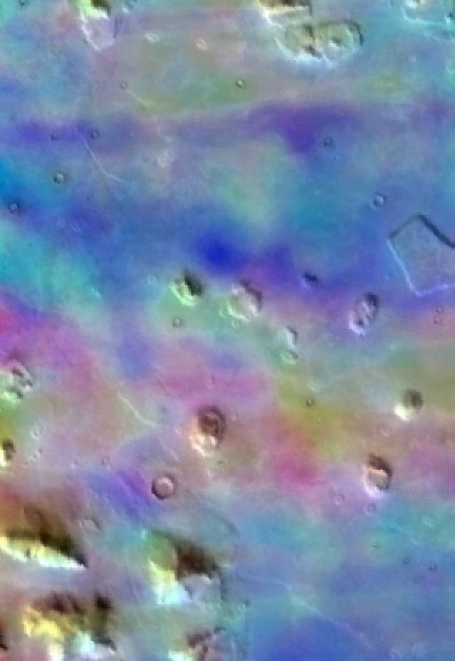
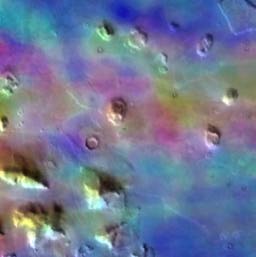
An analysis of a recent THEMIS multispectral image (20020724A.gif) acquired by the Mars Odyssey spacecraft over Cydonia provides further evidence that an ocean once existed to the north, and that the features known as the City and Face are located along what was once its shoreline. It is shown that there are three spectrally distinct regions that are spatially correlated with MOLA-derived elevation data. One region is correlated with the higher terrain to the south, another with the low-lying plains to the north, and a third with a transition zone between the two. From its topography, relationships to the terrain to the north and south, spectral characteristics, and morphology of its features, it is conjectured that this transition zone was once the shoreline. The City, Face, and D&M Pyramid all lie in this zone. As either shoreline features, or even possibly islands, their proximity to water provides a possible explanation for how these once-symmetrical structures could have been transformed into their present, collapsed and highly eroded, state. [ From: New Frontiers in Science - Vol. 1, No. 3 (Spring 2002) - by Mark Carlotto ]
|
|
Analyses of the Mars Face
|
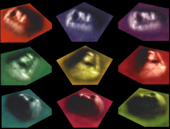
Three dimensional renderings by Mark J. Carlotto, PhD
Interpolated from his famous Shape From Shading technique which analyzed the original Viking photos in 256 color grayscale and determines a pixel's altitude in elation to the ones surrounding it very much like we are able to tell the shape of an object with one eye closed.
Images from the cover of "The Case for the Face" ~ edited by McDaniel and Paxson. |
Staredown
What one piece of substantial evidence would possibly cause people to
believe that life, Human life, was once thriving on the planet Mars?
Of all the amazing things discovered in the 20th century this one
chance find could prove to be the pinnacle turning point in our modern
history.
But NASA officials and the media at large dismiss the Face - easily
poking fun at the many, once esteemed, scientists who dare to analyze
it.
And analyze it, they have - but what they've found goes against
everything our society is founded on.
Most Cydonia investigators have put their careers on the line, and even their health in jeopardy, searching for a truth too possible to ignore - and too important to write off as fantasy. Even admitting their arguments are well based, that the inescapable conclusions may possibly have some merit, and that the whole subject warrants further investigation, can put a colleague in the column of dissent. Thus, many do not - and, the sham goes on.
A veil of secrecy also remains around the recent controversial redating of the Sphinx - and thus, likely the entire Giza complex, pyramids and all, putting its construction at approximately 10,500 BC. This date figures in with pre-existing Atlantis "myths" and the Great Flood of Noah's Ark as well. Thus, Cydonia has since become a landmark find for serious Atlantis theorists,
as it further lends support to their theories of Man being much older than our history allows.
The main reason why people usually can't subscribe wholeheartedly to the Face being a real artifact is their struggle with the implications. What it means is: that there was life on Mars long ago, Humanoid life, and probably our distant ancestors - thus, our entire view of history must be rewritten. But many of our current institutions, from government to religion, have a stake in the status quo - hence the controversy. |
Most scientists are not on the cutting edge of research, just regular people doing their jobs. Dedicated and sincere though they may be - as a group, they're not particularly excited about any fascinating new discoveries or paradigm shifts, thank you. Besides, anything extremely off the beaten track, that also contradicts their research: if proven, could leave them quickly out of a job. Another reason why guessing wrong early can leave a species perpetually planetbound - the inability to go where the science leads.
If the Face were an aerial shot of some place on Earth, no one would have any problem with it. Teams of scientists would immediately be dispatched to the site to determine its origins - and many believe that this is in fact what has happened. But even if black project technologies are not yet advanced enough for this to have occurred as yet, this is most assuredly why it's being kept a secret. In fact, once we finally get to Mars, as a settling force, these sites will likely be strictly off limits to all unauthorized personnel.
It is a certainty that Viking I saw what it did, in two different images, on two different sunny days - one in the mid afternoon, the other closer to early evening. But even if it is an optical illusion, or as they say, "a trick of light and shadow," imagine flying over the Face as a tourist or settler a hundred years from now. The skies over Cydonia might be very crowded on sunny afternoons, if that turns out to be the only time of day when a Face can be made out from the contours of the mound. Until then, Carlotto's colorful 3D renderings (below), taken from the cover of The Case for the Face, may have to do. |
|
|
The Face of Truth The object in question is approximately 2.5 kilometers long, one kilometer wide, and 400 meters high. That translates to roughly a mile and a half long, just over half a mile wide, and a quarter mile high. Of equal megalithic proportion, in the immediate vicinity of the Face, are many other curious structures of similar size and interesting arrangement. So, one might easily say: that absolute proof of Human existence outside of Earth's protective atmosphere has been leaked to the public from NASA archives. But, until manned missions are sent to the Cydonia region Mars, and possibly even after, there will always be skeptics to say that it's just a bizarre coincidence. In the meantime, all we have to go by are a handful of satellite images - the enhanced versions hotly disputed my mainstream science.
While the images are enhanced, they are not fake. In image processing terms, "enhanced" means: to bring out more detail not easily seen in the original image. The human eye can see about 32 shades of gray, while the raw binary data from Viking was four times more accurate, at 128. This higher number is especially helpful in image processing, when more detail becomes visually clear by simply increasing the contrast in 256 grayscale. |
The first step in the Shape From Shading technique, developed and utilized by Carlotto, is to convert the raw data into pixels.
Bear in mind that each pixel covers an area about 50 meters across (over 160 feet), a total of 250 square meters.
In order to bring out details smaller than this, Pixel Replication replicates each pixel, thereby making the image larger,
- although some "appropriate" contrast is applied, it does not yet increase the effective resolution.
The next step is Pixel Interpolation, which applies an algorithm to the data to determine the slope,
and therefore the physical shape of the substance recorded by the imager
- in effect, "a statistical analysis of the data provided by the pixel relationships"
which is often able to derive "unseen" values and thereby recover the original shape of the subject of the photograph.
There are various types of techniques, using different algorithms, taking into account different groupings of adjacent pixels - each with unique characteristics and success rates when applied to known objects. These techniques are otherwise widely accepted as credible, and are basically just "reverse engineering" the way the camera gathers its data in the first place. The Starburst Pixel Interleaving Technique (SPIT) was developed by NASA scientists and Viking frame "rediscoverers" Vincent DiPietro and Gregory Molenaar, and takes a total of twelve surrounding pixels into account while converting each pixel into nine of more accurate detail, and thereby tripling the resolution. Image enhancement and extrapolation techniques of this sort, and more advanced, are used extensively today by security and intelligence agencies, and even the entertainment industry, for anything from clearing up static, to satellite photography, to (ironically) facial recognition. Even in "the face" of supposed ridicule for validating observations that the Face on Mars is an artificial artifact, the science is not being put to question (after all, our world has been made brighter and clearer because of it). The only thing that people seem to be bothered by is the inescapable conclusion that there is something intelligently constructed on the
surface of Mars. |
"Isometric plot of the 3D reconstruction obtained using the single image
Shape From Shading algorithm on NASA Viking frame 70A13.
A similar result was obtained for frame 35A72."
~ Dr. Brian O'Leary, space scientist
|
|
More Than Meets the Eye
Upon further investigation of the original Viking frames and later enhanced images, other more "subliminal" features eventually presented themselves to several squinting researchers, working independently. Not all of these curiosities showed prominence in the high resolution MGS photos released by NASA in 1998, however - and all are summarily dismissed as merely products of enhanced noise, somehow coincidentally in both original Viking images.
Closer looks at the Face revealed several interesting and seemingly contextual artifacts: such as a Pupil, Teeth, a Teardrop (above right),
the very noticeable parallel Stripes or Notches at the side of the helmet (below left), and especially exciting center symmetrical cross-hatched etchings at the top of the helmet (below right). The outer shape of the Face mound is a symmetrical oval with flattened sides, possessing further symmetry and apparent contextual overall design.
In addition, these further details, painting a more detailed portrait, do tend rule out chance erosion as a likely cause for the increasingly improbable shape of the mound.
The Pupil did in fact turn out to be a grouping of very dark pixels in the original data; but the Teardrop (above right), is shown to be an actual surface feature in recent photos (inset below) - a molehill upon a mountain, of sorts. Roughly the size of an average suburban dwelling, it too stands out from the general area, being by far the most prominent object in its local area.
The Teeth remain even more a subject of controversy
- but the feature is shown in modern images to be a ridge parallel to the Lips marking the top and bottom of the Mouth area.
Contextual references will apparently have to be authenticated by manned archaeological missions.
In this case, beauty is in the eye of the beholder.
Prominent Crossed Lines over the eyes, on the Helmet's top (left), also
refused to vanish upon closer, more modern inspection;
and strengthen the initial impression that the Helmet appears reminiscent of a Pharaonic head-dress,
as seen throughout ancient Egyptian art, the theme of which also being associated with giant pyramids.
Perhaps another outlandish if controversial connection is to the many depictions of Ancient Astronauts from various cultures worldwide
- only realized as these obvious depictions in modern times, after the invention of space suits.
The side Notches, or Stripes (right), are also shown to be valid geological features in the MGS images, although perhaps somewhat less prominent than expected.
Perhaps it is fortunate that Viking flew over and photographed Cydonia,
twice
- and both at just the time of day when the Face would be most apparent
- otherwise we may not know about this ancient, fascinating and likely archaeological site.
Who knows how many other sites like this exist on the planet Mars, showing signs of ancient Human occupation, that we simply haven't found out about yet?
Some, like Elysium (also seen to have the almost requisite giant pyramidal shaped mounds), are being looked into
- but none so far are as intriguing as the region surrounding the Face.
Head of the Class
In 1996, a small group of students at North Kelvenside Secondary School
in Glasgow, Scotland undertook an independent investigation of the Cydonia anomalies
- and got a Martian mound, the NK Pyramid, named after them in the process.
Chris O'Kane, an audio visual technician at the school and the award winning developer of the Vistamorph panoramic photography system,
along with computer science department head Mike Turner, acquired extensive original image data from NSSDC, Viking I orbits 3 thru 70
- and recruited prominent Mars anomaly investigators Stanley McDaniel, Ananda Sirsena and Erol Torun to serve as scientific advisers for the project.
Working on ordinary PCs, that by today's standards can be considered quite primitive, they were easily able to discern further details of the Cydonia Complex, and focused their attention on several anomalies. One of the first things that they noticed, when examining the 22,000 square mile area, was that the other objects of Cydonia became more noticeable when the image was tilted so that the Face could be viewed right side up. While this could be an "artifact" of the shading provided by the afternoon sun in both images, it could also have been an intended effect in the site's construction.
|
Just as faces lose their familiarity when tilted, it seems the architects Cydonia applied this quality of the eye and designed the layout of the complex to be appreciated from a certain perspective, with north as up.
The Face itself was discovered to be extremely eroded, or damaged, on the eastern (shaded) side - as if by the very disaster that transformed the entire planet. The five sided D&M Pyramid was also examined closely, and observed to be symmetrically pointing north towards the Face, and to also have a damaged eastern facet. A number of other anomalies were investigated, all of which are now being given closer attention by Cydonia investigators.
That spring, they presented their conclusions at the Edinburgh International Science Festival, which was warmly received by both the audience and the national media, whose coverage was described by O'Kane as being "on the whole accurate and responsible." In an email to Dr. Michael Malin, of Malin Space Science Systems and in charge of Mars Global Surveyor imaging, they requested that the newly christened NK pyramid be imaged in the upcoming mapping mission. Malin wrote in his reply to the group that: "we cannot expect to 'hit' any specific target on Mars. Rather we hope to acquire representative images of many areas, including Cydonia." This was taken by many as being politely dismissive - and it was clear that the findings for the group were not being taken openly seriously by any official source.
The students concluded that the face is not symmetrical but that the left [east] side is collapsed, eroded or damaged and does not closely resemble the right [west] side. The Face does however have clear symmetrical markings in the form of lines on the forehead.....
A dark circular feature next to the eastern side of the structure is very unusual in that it does not resemble any other crater in the region which was studied. It seems to be a deep, dark hole which the sunlight does not illuminate. We could see the bottom of all craters in this region but we could not see the bottom of this feature. It was also noted that the axis of symmetry of the D&M Pyramid points north to intersect the Face. [ From: The Case for the Face, p. 77 - "A Picture's Worth" by Chris O'Kane ]
|
 |
Saving Face
When we went to Mars this time around, NASA was supposedly looking for something that we already knew was there. Despite the lack of seriousness surrounding their official position, NASA has, on the surface, been making every "reasonable" effort to photograph Cydonia. The only problem is, their data appears to be altered to more reflect their view on the subject - which is, and has always been, that the anomalies could not possible be artificial in nature and that "most scientists" consider it to be merely an optical illusion.
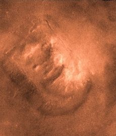
In a somewhat successful attempt to diffuse the mounting public fervor surrounding the Face on Mars, just one week before a new book by Cydonia investigative scientists entitled The Case for the Face was released, this "faceless" Mars Global Surveyor photo (above) was widely released by NASA on April 5, 1998. Mars Global Surveyor flew over the Cydonia site one sunny Martian morning and snapped this much clearer picture for us patient Earthlings. NASA promised they would pay special attention to images gathered of the region, and it seems on the surface as if they did. A national press release was issued that politely poked fun at the monument, asking: "does this look like a face to you?" - but accompanying the snide text were pictures that are out of contrast, and make the Martian mound resemble a disaster area. |
This is an unusual image, in that it was shot not from overhead, but at a 45° angle - and in the bright lighting of the early morning sun, instead of the afternoon sunlight and long shadows of the original Viking images. With the only available high resolution images of the Face being lit from the southeast, easily obscuring many details, NASA has again come under suspicion of trying to hide the truth from Face investigators. Although undoubtedly given many opportunities to photograph the site at multiple camera angles and at different angles of the sun, a modern high resolution westerly perspective afternoon picture of the Face has yet to be forthcoming.
The 98 MGS image actually does look like it used to be a face, but somehow suffered incredible damage - almost as if the evidence were conveniently destroyed. Some conspiracy theorists charge that the mound was bombed by clandestine probes, or even black project astronauts stationed on Mars. To be fair, top secret projects involving manned missions in space would explain much about the Mars issue, and beyond. But other research has confirmed that the east side of the Face appeared damaged in the original Viking photos, which is curiously consistent with other Cydonian monuments - and also with what we know, and can surmise, of ancient Martian global catastrophes.
In any case, the Face in the new image does appear significantly different from that in the original Viking photos, despite being the most conspicuous object in the region. NASA is using this as simple proof of their calm claim: that the Face is nothing more than "a trick of light and shadow" - thereby dismissing the entire region from public attention. Even if it never was a Face, the right angles incorporated in the object are still inconsistent with the rest of the surroundings - and still by far the most unnatural object by fractal analysis, moreso than most terrestrial man-made artifacts photographed from space. The investigation continues, armed with more accurate observations of the Cydonia complex - and in fact, the entire region. |
High resolution images of the Face, made from the original 1998 MGS image. False orange color added for contrast (left), and inverted to simulate lighting from the northwest (right). Click here to see the larger original full-size, black and white version (72K, opens in new window). |
|
from: Symmetry and Geometry
of the Face on Mars Revealed
A New Analysis Based on
the April 2001 Image
- by Mark J. Carlotto |
...a realization of new operational constraints imposed by the new
mapping scheme, has caused two sequencing errors over the last week.
On 00-048 (2/17/2000) at about 00:00 UTC, the new Beta Supplement
sequence, mm014b, was scheduled to kickoff but never went active.
Since that new sequence controls the tracking of the HGA to Earth, no
downlink was possible....
The net effect of the anomaly was the loss of most of DOY 48 recorded
science telemetry.
[ From: Cydonia: Two Years Later -
MGS Status Report - February 23, 2000 ]
|
Symmetry
It's still symmetrical. It still has parallel sides and symmetrically rounded opposite ends.
It's still aligned to other curious geometrical objects in the immediate vicinity.
It's still a monument centered upon a beveled platform - and it still looks like a face.
The Face on Mars is not a natural formation.
It may be hard to tell for sure whether or not it was, in fact, a human face;
but whoever made it
knew well about what ancient cultures on Earth called Sacred Geometry
- and they had the means to leave such a lasting impression on such a large outcrop.
But no sign of its repair after the cataclysm that swept across the Red Planet
and probably destroyed most of its ecosphere, making it the frozen desert it is today. |
Pyramid Cities
Unmistakable contours of ancient water flow, running roughly northwest to southeast
as if the City were located on the western bank of a great waterway, many miles wide
(to give you an idea of scale, The Face is a mile and a half long and a half a mile wide)
but these markings are on top of the fainter, more regular, seashore edge elevations
(many smaller tributaries and streams can also be made out, throughout this image)
as if a very high volume of water rushed suddenly past here - and then nothing more
compare to spectral image (below right) showing where the long-standing water was.
Cydonia City
The Monuments of the Cydonia region of Mars are perhaps the most fascinating ruins ever yet discovered by man - on any planet. On the shores of an ancient Martian ocean, now completely dry, Man's first probes to our nearest planetary neighbor have detected a group of mounds, surrounding the Face, that even at first glance appear unnatural and complex in design.
Further investigation of the mounds shows that they were in fact arranged in a definite complex geometric pattern - one that could not possibly have occurred naturally, and apparently required much thought and labor to create, by architects who knew more about mathematics than we have the even optimistic ability to half way decode today.
Predominant throughout the area, the angles implied by arrangement of structures within the City are of a relation to each other which suggests alignment to astronomical phenomena within this solar system - and beyond. |
Pyramids on Mars - composite of original Viking I frames 70A13 and 35A72, from 1976
showing the entire Cydonia Complex - and colored orange to bring out fine details. |
The significance of the geometry found here, and therefore artificiality of Cydonia, cannot be understated - and should not be underestimated. It seems to call to us, using the universal language of mathematics, in simultaneously beautiful and complex patterns: "we were here." Whether this was the site's intended purpose, or just the way that the ancient architects designed this awesome site for their own purposes; there are seemingly countless angles here, that through thorough invsetigation cast out any hastened notions of natural erosion or random occurance.
|
New Frontiers in Science -
Vol. 1, No. 3 (Spring 2002)
- by Mark Carlotto |
Included in the anomalies surrounding the Face are several giant pyramids - the chief among them being the massive D&M pyramid which has more mathematics associated with it than you can shake a slide rule at. Additional features include the Tholus, a conical shaped object just slightly bigger than the Face - and a Cliff, adjacent to a massive crater, together forming a giant number 10, which is perhaps the only coincidence in the entire region. A close group of smaller structures, named The City, contains over a dozen pyramid mounds - and a curious pile of rubble, that investigators have nicknamed The Fortress. Further off to the west, and only discovered relatively recently in neighboring Viking frames, are more pyramidial mounds and a possible second Face. Many more objects are likely to be identified as further high resolution MGS images of Cydonia, and in fact all of Mars, are released to the public.
All of these structures, besides jumping out at you on first glance, are aligned precisely to each other utilizing pheonomenally dynamic mathematical relationships; that scientists are only beginning to discover, much less understand their purpose. Given that these structures were laid out this way intentionally, it begs the question: why would someone go to so much trouble? Could they have been using Pyramid Energy to tap into the magnetic field of Mars, as a sort of infinite power supply?
Were they trying to send a direct message to anyone with enough math skills to know what they were looking at? And for that matter, do we even have the faintest idea just what it is that we are looking at, when we examine Cydonia? |
Seaside Spaceport
This unofficial dating of the unofficially archaeological Martian site fits in with theories of ancient civilizations, including the legend of Atlantis: that humans lived in this star system eons ago, settling on the inner planets, but suffered many cataclysms - their great and technologically advanced society passing into mythology.
One of the first things that archaeologists try to determine about a site that they investigate is its purpose. The Face is only recognizable from space, or very high up in the air, - so we can assume that they at least had some manner of flight capabilities, if not complete mastery of the skies. They certainly had mastery of geometry - and architecture, for that matter. Dwarfing the pyramids of Giza and Teohuanaco, the largest on Earth - each Martian mound is about a cubic mile in volume - such close similarity in size alone being more than enough to rule out natural formation as a possibility.
Situated on the shore of an ancient ocean, Cydonia seems at first glance like the ruins of a once great city. The way the craters have spilled over onto the surrounding terrain seems to indicate that the ground was very muddy, soft and heavy at the times of impact. Exactly where the waterline was at the time of construction and/or occupation is a question hopefully to be answered by future ground investigators. In the meantime, curious features like the Mesa (situated due east of the Face, about half way to the Tholus), and the Pyramid Island (just beyond it), are left to almost sheer speculation as to their purpose.
Although no obvious landing strips are apparent (unless certain mounds, or even the very pyramids themselves, may have possibly served this purpose), we cannot rule out that people capable of building such an impressive complex might have developed equally impressive technology regarding their transportation to and from the site. The Mesa could well have been such a landing pad for hovering craft to set down gently upon. If this object were also surrounded by water, along with similar neighboring objects, then the pyramids themselves may have been slightly submerged to a certain level - or there may have even been a variable beachfront along the urban Martian waterway. The texture surrounding the "10" Cliff and Crater seems almost fjord like - although that could in fact be entirely due to ejection, at the crater's creation.
|
cover of The Martian Chronicles
- by Ray Bradbury |
Further speculation may have to wait until we are able to determine more about the people who once lived here, and the cataclysm that destroyed Cydonia - most likely the very same disaster that turned Mars into the frozen desert that it is today. But there are the obvious telltale signs of running water - as if a river, several miles wide, were once running just east of the Face, so very long ago.
In addition to signs of shorline, many other signs of topographic varriation can be observed, suggesting minor waterways feeding the wider riverbed. Also, several sometimes winding tributaries can be identified on closer inspection, once you begin looking for them - one particularly prominent ancient stream is directly between the D&M Pyramid and the Tholus, at the very bottom center of the Composite picture (above).
While nearly all of the objects appear damaged, particularly on the eastern faces, some seem incomplete - as if Cydonia was a city under construction at the time of its demise. One particular mound, almost forming an equaliteral triangle with the D&M Pyramid and the Face, appears as though it would align more perfectly if it were enlarged to the east, to be a symmetrical duplicate of the D&M Pyramid. With all the angles and cosines and Golden Means employed at this site, few Cydonian Complex researchers would likely be surprised if this turned out to be the case.
As human beings, when we encounter strange archaeological sites, with no surmisable data on their origin or purpose, we tend to put them into terms that we can identify with. Nearly every ancient civilization we encounter, we tend to put into the category of ignorant and superstitious, primitive, tribal peoples; and sometimes this is a mistake. This is certainly not the case, however, with Cydonia, or any site we're likely to find on Mars. Perhaps this is the reason for the cover up - no one can know that we are not now at the height of intelligence and technology.
Today, we see a city on another planet and imagine a technological hub, like something out of science fiction. This seems very likely considering the vast technology needed to construct the site, in all its grandeur and mystery. But they could have been just people - people who were from a vastly different culture, one much older than ours and therefore more advanced, who knew something about the universe that we do not, some things that we can barely begin to understand about certain subjects that we do not yet know are related. Whether Cydonia was a spaceport, or a temple, or a city, or a power plant, or any combination of these; it most certainly was something important - and thus, it should be important to us.
Assortment of Dice - four-sided tetrehedrons (left), twenty-sided icosohedron (right).
The tetrehedron is a pure geometrical form, found prevalent throughout the Cydonia Complex.
A Certain Latitude
A good place to begin an understanding of Cydonia is with the tetrahedron (right). A tetrahedron is a simple three dimensional shape, consisting of four equilateral triangles, forming a three sided pyramid (right). One of the simplest three dimensional shapes, only the sphere and cube bear such elegance and simple perfection - and the tetrahedron is by far the most unlikely to occur naturally. Another universal shape, though not quite so simple: involving, and entirely consisting of equilateral triangles; is the icosohedron, or twenty sided die (above right) - which, with tetrahedrons as four sided dice (above right), are used in games like Dungeons and Dragons. These shapes are known for their engineering stability, as in Bucky Balls or Geodesic Domes (below left) - and, like the arch, is almost entirely self supporting.
Perhaps one of the most intriguing universal constants found at Cydonia involves the mathematical harmony of tetrahedrons and spheres (below right). When a tetrahedron is placed inside a sphere of equal diameter, with a corner at a pole, the opposite side and remaining three corners land on exactly 19.5° latitude - an angle that continually shows up again and again in the more and more assuredly artificial structures of Cydonia. This is a fixed angle: no matter what their size, as long as the tetrahedron and sphere have the same diameter, you will always arrive at 19.5° past the equator. The numbers themselves are perhaps unimportant, as these relationships are "analog" universal constants, apart from our "digital" interpretations of a 360° circle. But this special angle is just as valid as, say, a 60° angle for an equalateral triangle - though perhaps more advanced, which only makes it even less likely to be a quirk of fate. At the end of the day, this alone could keep serious scientists looking into Cydonia. |
 |
 |
The significance of 19.5° to Cydonia is only taken into account when the angle keeps popping up in repetitive measurements of the structures. A line from the Teardrop on the Face to the D&M Pyramid is at a 19.5° angle to a line from the Teardrop to the City Square. Certain prominant angles on the D&M Pyramid itself are at a 19.5° angle to the Martian lines of latitude, and thus perpindicular to the Martian poles. The Root-2 Mounds, a collection of smaller mounds within the City arranged at the corners of a grid based on the square root of two, also most frequently relate to each other with the tetrahedral angle.
If there were several dozen right angled structures on Mars, all arranged very much like a modern Earth city, or if the number 3 kept popping up everywhere you looked, few would doubt the validity of the theories of artificiality - although some would still argue that there must be some "rational" explanation besides Human intervention. But these are Cosmic Numbers - and go beyond 30° or 45° or even 90° and suddenly puts it into the category of "irrational" or even "surreal" numbers - boosting the importance and obviousness of artificiality, and by a group of technologically advanced architects. The only thing missing is the big neon sign saying: "Here I am, notice me!" This is also, perhaps equally uncoincidentally, the latitude chosen for the landing site of the Mars Pathfinder mission (below left). Could NASA be taking Cydonia more seriously than they let on? |
Assuming that NASA has their head on slightly straight, if clandestinely, regarding Cydonia and the 19.5° angles found throughout - perhaps the Pathfinder landing site was pointed to by one of the pyramids, or some other such structures for that specific longitude. This methodology works completely outside the theory that Mars was once rotating differently, having suffered a pole shift in the disaster that changed the face of Mars. One theory, to be discussed more thoroughly later, has Mars as a moon of a larger planet that is now the Asteroid belt. This Exploded Planet Theory also has the Face situated at a geocentric point closest to the mother world. With Cydonia located on the equator and aligned perfectly to the north pole.
Considering for a moment that the builders' purposes had absolutely nothing to do with drawing attention to the site, that's just the way they did things - and taking into account just what we know so far about pyramid energy, focussing electromagnetic energy to a central point through perpindicular planes - it seems as though the ancient Cydonians may have been somehow using the arrangement and planetary placement of the pyramids to generate electric power for their Martian civilization, by tapping into the once strong magentic field of the Red planet. The Face, though situated with equal precision, could be said to be purely asthetic otherwise
- although some investigators have detected what may be entrances to a set of tunnels burrowing deep underground.
In any case, 19.5° is a significant benchmark in spherical geometry - and cannot be considered a coincidence under any circumstances. It also speaks directly to the pyramidal forms found throughout the region, and tetrahedral pyramids in general. In addition to the tetrahedral latitude, we find the square roots of 2, 3 and 5 demonstrated throughout the Cydonia Complex. Scientists are currently looking into what the relationships between these numbers possibly can tell us about the site. But it doesn't take a rocket scientist to see that these mounds are more than randomly formed Martain rocks.
Perhaps the advanced nature of the mathematics was intentional - too far out of reach for primitive cultures to grasp, or be interested, or even notice in the first place. If it were easy to explain to the masses, there would be a mass public outcry for manned expeditions. Perhaps the site was designed to call attention to itself, but only to those who are ready to accept it - and ready to deal with what Cydoinia has to tell us about our own past. It goes against everything that we've been taught, that our centuries old society has always believed. To suggest that we are not alone in the universe is controversial enough - but far less heretical than the idea that it was actually our distant ancestors who built Cydonia. Perhaps it is only when we can look beyond the veil and think for ourselves, that we will be ready to understand the truth of Mars. |


|
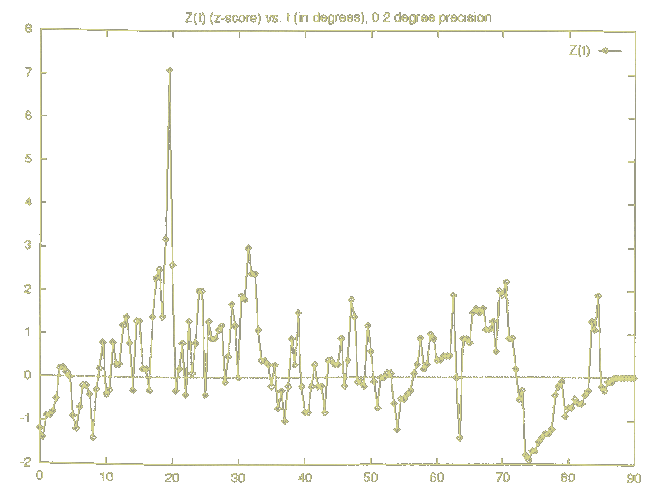
Nonrandom Distribution of Angles - by Professor Stanley V McDaniel
The accompanying graph is a dramatic representation of the "signal in the noise" that, among other evidence,
has convinced SPSR scientists that the Cydonia area deserves high priority for investigation by NASA.
...Random geology would expect a z-score in magnitude no greater than 2 or, to be conservative, 3, for this particular site. Instead we have a sharp peak, representing a z-score of 7.42 precisely when the angle t equals 19.5 degrees, representing one particular set of isoceles and right triangles. It turns out that this particular set is the one containing the same angles as those measured under GADE. Thus the prediction was fulfilled that, if the angles from GADE were significant, the number of times these angles appear among the remaining mound angles would be far beyond chance. The z-score of those angles is so high as to rule out chance as playing any significant part whatsoever in the distribution of the actual mounds.
|
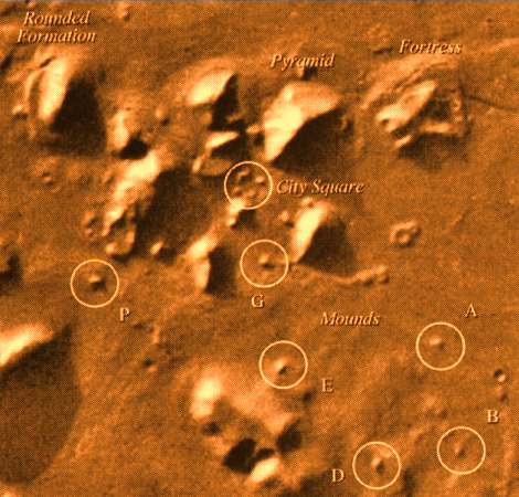 |
Smaller Mounds in the Complex Arranged with Sacred Geometry
Analysis of the positions of various smaller mounds within The City
shows their geometrical relationships based on universal constants.
The position of mound D marks the center of a side of a tetrahedron.
Trigonometric Proportions of the City of Pyramids - at Cydonia, Mars (above)
This diagram of smaller mounds within the "Pyramid City" of the Cydonia Complex
shows their difinitively symmetrical, non-fractal, and ovbiously artificial arrangement
on a mathematical grid based on the cosmic ratio of one to the square root of two.
The Way of the Ancients
Like the Pyramids at Giza and Teotihuacan, the more you look at the Cydonia complex, the more amazing features and unlikely coincindences you will see.
It is as if the designers were voicing their existence to a future Human culture - saying that they were there; they were human; that they knew about the stars, geometry and physics; and they knew how to build massive monuments as big as mountains. This is something even we, with our "nuclear bombs and striped toothpaste" have incredible difficulty with. Although we are able to eventually accomplish some of the engineering feats demonstrated here - it makes more economical sense, for now, to stick to our familiar brick and metal buildings of average size. But the ancients didn't leave anything like this behind, or none of it has survived. The thing of it is, this is exactly the type of messages we send out with space probes to hopefully one day greet alien cultures with - only far more advanced. We are only now, with our modern technological advances, able to recognize these "Temples of the Gods" as something almost within reach, but still far beyond anything we are able to duplicate today - or would have thought of on our own. Perhaps we already did though, so very long ago.
One of the more interesting formations in Cydonia is a curious collection of Mounds within the area dubbed The City. Although easily overlooked, closer inspection of the anomalies reveals, to even the naked eye, that some of the mounds are equidistant - and upon closer inspection, even further beyond the realm of chance, they are arranged at the corners of a grid based on the square root of two (above right). That is: if the distance separating the parallel lines running roughly east to west were said to be one, then the distance between the parallel lines running roughly north to south is the square root of two. These mounds are also obviously purposefully arranged in a trigonometric design found in the fundamentals of ancient Sacred Geometry. |

Diagram of Martian Mounds arranged on a grid based on the square root of two |
 |
Again and again at Cydonia, we find mathematical relationships that
could not possibly be a coincindence or occur naturally.
Mound D, on the Root 2 Grid, is positioned exactly to represent the
center of a tetrahedron (left).
The 19.5° tetrahedral angle, as explained above, is also repeated
throughout the Cydonia Complex.
Even conservative investigators urge that, if the formations are
somehow natural, it is certainly an interesting phenomenon worthy of
further investigation.
But why this partcicular mound, and what is its purpose?
Like a bridge, or a back yard patio, these "molehills" are somewhat
indicative of something massive, once raised high above the surface of
Mars.
Some even speculate that these regularly spaced Mounds could be
remnants of a much larger structure, like a platform - or perhaps even
an ancient runway.
Whatever their purpose, even if it was to simply bring attention to the
site - and it certainly has gotten ours
- our knowledge of this system of numbers has no known origin.
It is found in nearly every ancient archaeological site on every
continent on the planet.
Sacred Geometry dates back long before recorded history - likely to
Atlantis, and beyond. |
Also known as Pythagorean Geometry, followers of the Greek philosopher
Pythagoras would in ancient times greet each other with secret symbols
of this nature.
Like something out of a spy movie, one would offer the other an apple,
and the other would cut it at the equator to reveal the pentagram shape
of the core.
Investigators of secret societies speculate that this was but a small
part of a much larger bulk of high knowledge
- handed down through countless generations, from Atlantis, to Noah -
and even to the inner circles of power today.
The layout and design of monuments and major government buildings in
Washinton DC utilize these relationships - perhaps the most conspicuous,
the Pentagon.
It comes as no surprise, to those who study these relationships, that
NASA is strenuously avoiding all possible public acknowledgement of
Cydonia.
But even the emblems for individual space missions contain these subtle
references, much like the ancient Pythagoreans.
Sacred Geometry is where art and science come together
- yin and yang, left brain and right brain, male and female, the
material world and the supernatural, the known and the unknowable.
Demonstrating an understanding of these relationships is more than a
declaration of intelligence
- it is also perhaps one of the most powerful methods of connecting
with cosmic forces, that we are only now beginning to imagine.
A connection between an ancient signature form of architectural design
and monuments on Mars is profound in the extreme.
This would prove beyond any reasonable shadow of doubt that this is not
the first generation of Man that has ventured to the stars.
The missing link to uncovering the truth, and identities of the
builders of Cydonia, may be Atlantis - cataclysmic disaster being
another common theme.
The five basic ratios of Sacred Geometry are very simple and easy to
remember - Pi, Phi, and the Square Roots of Two, Three and Five.
In rounded values, Pi is 3.1416, Phi is 1.618, the Square Root of Two
is 1.414, the Square Root of Three is 1.732, and the Square Root of Five
is 2.238.
These are all irrational numbers, defined by the phenomenon that you
can compute them digitally, in the decimal system,
into infinity and never discover their exact value - so far as anyone
has ever been able to compute, that is.
All of them are simple, elegant and perhaps mysteriously aesthetic.
Additionally, these numbers all take on a more profound meaning when
expressed as ratios - as x compared to one, or "The One."
According to geomancers, "The One is where it begins" - which is ironic
and poetic enough to be associated with the cosmic brand of mathematics
involved.
They are all found in abundance at Cydonia.
|

|
Pi (3.1416) is perhaps the most famous of these, found in the
formulas for measuring a circle - an obvious, easily expressed and
naturally infinite line.
In a perfect Circle (above, left), any radius (CD) is equal to exactly
half of any diameter (AB) - and the circumference equals the diameter
times Pi.
Pi is a transcendental number, and therefore cannot be described with
the same degree of accuracy as the physical square.
The Circle is considered ideal for spiritual activities throughout
history - and many sacred spaces are circular.
In sacred geometry, the circle represents the spiritual realms, while
the square represents the physical and material world.
The Circle is also considered to be Yin, while the Square is considered
to be Yang.
Phi (1.618) is the Golden Section of the Greeks. It was said to
be the first section in which the One became many.
The Phi ratio is expressed in the line ABC (above, center), where the
shorter length AB relates to the longer length BC, as the longer length
BC relates to AC, or the entire line.
Start at The One, or one, and add it to itself to get two. Add this to
the previous number to get 3. Do this repeatedly to get 5, 8, 13, 21,
etc.
The progression of fractions 1/2, 2/3, 3/5, 5/8, 8/13, 13/21 (and so
on) come closer and closer, but never actually reach the exact figure of
the Phi ratio.
The Square Root of Two (1.414) - is most easily discovered when measuring the cross section of a perfect Square (above, left).
In a Square (ABCD) with four equal sides having the value of One, the diagonal (AC) equals the Square Root of Two.
Thus, the length of any diagonal of a perfect square will equal the Square Root of Two times the length of one side.
This is the crux of the relationships of the ratios of all of these numbers, when compared with "The One."
In Sacred Geometry, the Square represents the physical world, as "it can be defined totally."
If its side is one, its perimeter is exactly four, and its area is one square - exactly. The Square is yang.
The Square Root of Three (1.732) is demonstrated in the Vesica Pisces (vessel of the fish) - a Sacred Geometrical figure where two Circles intersect at a certain very cosmic point (right). In this simple diagram, lengths A and B relate to each other through the Phi Ratio - that is, if the shorter length (A) is said to be one, the longer length (B) is equal to the Sacred Geometrical value of Phi (1.618). The Vesica Pisces is found throughout Old World architecture, in the form of the arch (below left) - which is also the root word of "architecture." This specific formula is the basis behind classic arches found especially in European churches, and especially from the Renaissance Era. In this diagram, line AB is said to be one (as is the distance between point C and either point A or B, to further the elegance of the ratios), and the other radius of the internal oval, or subset, line CD is thus equal to the Square Root of Three.
Just one of those interesting coincidences? Not hardly. Even this little, most basic level of knowledge of things like this was closely guarded by secret societies of the middle and dark ages, and before. The strange rituals that still survive in the form of bizarre initiation rites of college fraternities have their roots in the ancient "Keepers of the Ancient Wisdom" from the Free Masons, to the Knights Templar - to the Royal Houses of Europe, the Cathoic Church, and even NASA, today. If the "Powers That Be" have known about this phenomenon of mathematics for centuries, and they have been given the "Sacred Geometrical" data on Cydonia, why do they still publicy scoff at the Face on Mars? The answer is simple - "They" don't want it to become "Public Knowledge." Beyond this is cause for great speculation - but the proof is in the numbers.
The Square Root of Five (2.236) is most easily found in the Double Square (right) - that is, two squares placed side by side. In a rectangle where the short side is 1 and the longer side is 2, the diagonal is equal to the Square Root of Five. More interesting math: (root 5), 2.236 = .618 + 1 + .618 = Phi + .618 - or, Phi minus one, then times two, then plus one - simple, eh? That's the thing about Sacred Geometry - you can juggle it around any way you like, and they all still relate to each other very simply. These are the same phenomena that the Pyramids of Egypt and Mexico are based on - and Stonehenge, and many other ancient Sacred sites around the world.
The Square Root of Five relates to Phi by creating a circle from certain key points in the Double Square (left). Create a Square (ABCD), bisect the square (EF), thereby creating two Double Squares from the original Square. Now draw a line from the middle of the base to an upper corner (ED) - the ratio of lines EC to ED is One to the Square Root of Five. Create an arc using ED as a radius, intersecting horizon BC at points I and H. Lines IB and CG both equal exactly 0.618 - thus, lines IC and BG both equal 1.618, which is Phi. Additionally, Square ABGH is known as the Golden Rectangle (having sides with ratios of 1 to 1.618, or One to Phi). Continue the arc to create a full circle, in which a Double Square fits perfectly into (the original Square, plus its mirror image duplicate, across the horizon). The sides of the original Square said to be One, the radius of this circle is equal to One Half of the Square Root of Five, or Phi minus One Half. There are many more dynamic relationships in this simple diagram, which are also laid out at Cydonia.
The Square Root of Three (1.732) is demonstrated in the Vesica
Pisces (vessel of the fish)
- a Sacred Geometrical figure where two Circles intersect at a certain
very cosmic point (right).
In this simple diagram, lengths A and B relate to each other through
the Phi Ratio
- that is, if the shorter length (A) is said to be one, the longer
length (B) is equal to the Sacred Geometrical value of Phi (1.618).
The Vesica Pisces is found throughout Old World architecture, in the
form of the arch (below left) - which is also the root word of
"architecture."
This specific formula is the basis behind classic arches found
especially in European churches, and especially from the Renaissance
Era.
In this diagram, line AB is said to be one (as is the distance between
point C and either point A or B, to further the elegance of the ratios),
and the other radius of the internal oval, or subset, line CD is thus
equal to the Square Root of Three.
Just one of those interesting coincidences? Not hardly.
Even this little, most basic level of knowledge of things like this was
closely guarded by secret societies of the middle and dark ages, and
before.
The strange rituals that still survive in the form of bizarre
initiation rites of college fraternities have their roots in the ancient
"Keepers of the Ancient Wisdom"
from the Free Masons, to the Knights Templar - to the Royal Houses of
Europe, the Cathoic Church, and even NASA, today.
If the "Powers That Be" have known about this phenomenon of mathematics
for centuries,
and they have been given the "Sacred Geometrical" data on Cydonia, why
do they still publicy scoff at the Face on Mars?
The answer is simple - "They" don't want it to become "Public
Knowledge."
Beyond this is cause for great speculation - but the proof is in the
numbers.
The Square Root of Five (2.236) is most easily found in the
Double Square (right) - that is, two squares placed side by side.
In a rectangle where the short side is 1 and the longer side is 2, the
diagonal is equal to the Square Root of Five.
More interesting math: (root 5), 2.236 = .618 + 1 + .618 = Phi + .618 -
or, Phi minus one, then times two, then plus one - simple, eh?
That's the thing about Sacred Geometry - you can juggle it around any
way you like, and they all still relate to each other very simply.
These are the same phenomena that the Pyramids of Egypt and Mexico are
based on - and Stonehenge, and many other ancient Sacred sites around
the world.
The Square Root of Five relates to Phi by creating a circle from certain
key points in the Double Square (left).
Create a Square (ABCD), bisect the square (EF), thereby creating two
Double Squares from the original Square.
Now draw a line from the middle of the base to an upper corner (ED) -
the ratio of lines EC to ED is One to the Square Root of Five.
Create an arc using ED as a radius, intersecting horizon BC at points I
and H.
Lines IB and CG both equal exactly 0.618 - thus, lines IC and BG both
equal 1.618, which is Phi.
Additionally, Square ABGH is known as the Golden Rectangle (having sides
with ratios of 1 to 1.618, or One to Phi).
Continue the arc to create a full circle, in which a Double Square fits
perfectly into (the original Square, plus its mirror image duplicate,
across the horizon).
The sides of the original Square said to be One, the radius of this
circle is equal to One Half of the Square Root of Five, or Phi minus One
Half.
There are many more dynamic relationships in this simple diagram, which
are also laid out at Cydonia. |
|
The Pythagorean Theorem (right) states that A˛+B˛=C˛ in any right
triangle.
The 3-4-5 Right Triangle is perhaps the easiest to understand, as
9+16=25 - the phenomena in its simplest form, the lowest common
denominator.
The corners also measure in at 30° 60° and 90° quite aesthetically - and
is thus the gateway to understanding Trigonometry.
Keeping in mind the Sacred Geometrical passion for the Square Roots of
2, 3 and 5, the middle value can also be said to be 2 Double Squared.
Sacred Geometry is also highly concerned with the values of 2 and One
Half, and their mirror complimentary relationship to One - or, The One.
But even if this is just a pile of interesting numbers, there are far
too many 3-4-5 Right Triangles in Cydonia to be considered a product of
chance.
If you were to see a house or a city with as many, you would think the
residents or architects had "a thing" for the shape itself.
Apparently, the designers of the Cydonia Complex did indeed have "a
thing" for these most basic, yet not naturally occurring, phenomena of
Sacred Geometry.
One very interesting example of Sacred Geometry prefectly demonstrates
the relationship between the Earth and the Moon (bottom, right).
Take a square and place a perfect circle inside so it touches the
square at the midpoints of the four sides.
Say the diameter of the circle and the length of each of the sides of
the square is 11.
Take two 3-4-5 right triangles and place them at either side of the top
of the square, with the 4 side down (like a roof on a house)
- this leaves room for a square in the center, with its sides being
exactly 3.
Place a second circle inside this second square, as in the first pair
below.
The ratio between these two circles is exactly the same as that of the
Earth and the Moon!
Perhaps this seems at first like an overly complex way to demonstrate
the ratio between two prime numbers, 11 and 3
- but now, draw a line between the center points of the two circles,
and use that as a radius to draw a third circle.
This new, largest circle crosses the original square, with the corners
sticking out slightly (and there are other interesting measurements
associated with that)
- but perhaps the greatest coincidence is that its circumference is
equal to the perimeter of the larger original square!
There are many other interesting geometrical alignments within this diagram.
The great pyramids of Egypt, Mexico and China are based on this phenomena
- this is how they align to the cardinal points and the dimensions of the Earth.
These relationships are found throughout the Cydonia Complex, but the pyramids of Cydonia are mostly five-sided
- so use more involved ratios in addition to the relatively simple formulas shown here.
Many of these we are just now beginning to understand, but are natural extensions of the ancient wisdom of Sacred Geometry.
In popular science fiction, a common theme for the imagined culture of
Martians (apart from being short and green)
is advanced mathematics, with a numerical system based on Three - and
even architecture based on complex Triangles.
These may all in fact turn out to be the case - but what if the Martians
are real, and turn out to be our very distant ancestors?
Sacred Geometry
Dr. Horace Crater's Diagram of alignments
within The City showing mounds arranged
in equilateral and right triangles on a grid
with the ratio of one to the square root of two.
|
Dr. Horace Crater's Diagram of alignments
within The City showing mounds arranged
in equilateral and right triangles on a grid
with the ratio of one to the square root of two. |
The geometrical D&M Pyramid points to the Face
at a 19.5° angle relationship to the center of the City |
Focal Point
The D&M Pyramid (named for prominant Cydonia investigators Vincent DiPietro and Gregory Molenaar, the original Viking project scientists who re-discovered the controversial Viking frames) could just as easily stand for the Diamond of Mars. The shortest of the five sides being about a mile long, its longest axis about two miles, and standing about a half mile tall, this small mountain checks in at about a cubic mile in volume. As gigantic as any other monument in the immediate area, it may very well be the Rosetta Stone of Cydonia - the key to understanding the ancient Martians designs.
This massive and impressive structure might certainly seem at first glance to be just another unassuming rock formation
(and it is certainly being dismissed as such, at least publicly) but it
is actually a complex example of Euclidean Geometry.
Almost overshadowing the Face itself as a centerpiece for the entire Cydonia Complex,
the D&M Pyramid is full of the same cosmic ratios found throughout the monuments of the area, in both orientation and design.
This five sided pyramid, is aligned to the Martain Cardinal Points with
an unmistakable pentagonal outline
- and also points directly to the Face, the City Center and the Tholus (right)
at coincidentally the very same precise angles seen throughout Sacred Geometry.
This phenomenally elegant and ancient branch of mathematics, known to us
as Sacred Geometry,
that are used in the design of many ancient archaeological sites on Earth: such as Stonehenge in Southern England,
the Sphinx and Pyramids at Giza near Cairo in Egypt, and the Mayan Pyramids of Teotihuacan, just outside what is now Mexico City.
In fact, it is impossible to look at these sites as they really are, without realizing that they were built by the same culture (or, at the very least, related cultures).
|
|
Its line of symmetry points north and directly to the Teardrop on the
Face, just below the right or western Eye
- the distance between these two points being, amazingly, 1/360th the
polar diameter of Mars.
The northeast line can be extended to intersect the Tholus, a massive
conical formation roughly twenty miles to the east.
A mirror line, to the northwest, projects to the center of a close
arrangement of mounds in the City, known to investigators as the City
Square.
In a triangle drawn between the Teardrop, the north point of the
D&M Pyramid and the City Square, the angle at the Teardrop is 19.5° -
the tetrahedral latitude angle.
|
In 1988, cartographer Erol Torun developed a hypothetical model of the
D&M pyramid's original shape (above)
and determined that the structure incorporates many "facets" of
Euclidean Geometry.
In addition to the tetrahedral 19.5° angle, numerous trigonometric
functions are identified,
involving the irrational numbers Pi, Phi and the square roots of 2, 3
and 5 - the five main foundations of Sacred Geometry.
The dimensions of the D&M Pyramid are approximately 1 mile by 1.6
miles - extremely close to the Golden Section ratio, utilized in Sacred
Geometry
(that the units are in fact miles is the subject of another discussion,
involving the ancient origin of miles as units of measure),
and well within natural erosion parameters to take for granted that the
pyramid was constructed with these very prevalent dimensions also in
mind.
In perhaps the most stunning observation in the whole Cydonian Complex,
and what writer Graham Hancock calls "The Rosetta Stone" of the Cydonia
Complex,
Richard Hoagland found that Leonardo DaVinci's Vitruvian Man (left) may
be perfectly superimposed upon the D&M Pyramid
- as if the structure were designed to communicate the concept of
"humanoid proportions" across the ages.
This Phi ratio is extremely aesthetic in nature, and nearly everything
about the design of the human form incorporates these ratios
- everything from the length of our limbs and the digits of every
finger; to the proportions and size of the human head and even our belly
button.
To deviate even slightly from these precise measurements gives one an
odd appearance, and is instantly perceived by others, even
unconsciously.
The five pointed star, with Phi, is also very prevalent in the
arrangement of the face - everything from eyes and nose to cheekbones
and dimples.
These relationships are all to be found in the exact same proportions on
the Cydonian Face as well. |
From: The Case for the Face - by McDaniel, Paxon, et al - p. 285
[In 1988] Erol Torun, a cartographer at the Defense Mapping Agency in Washington DC,
undertakes a geomorphological and geometric analysis of the object called the "D&M Pyramid" (after DiPietro and Molenaar).
He proposes a hypothetical model of the original shape of the formation, which appears to be geometrically sophisticated
and to express numerous universal mathematical constants.
He concludes that no known geological process can adequately account for the formation.
Following Torun's hypotheses, Hoagland claims that the same universal constants
may be found in geometric relationships between the D&M Pyramid and other nearby objects.
He calls this group of objects the "Cydonia Complex"
and argues that the latitude of the D&M Pyramid may be expressed in terms of those constants.
|
Cosmic Spiral
The Cydonian Golden Mean Diagram (below, right) shows the advanced artistic, mathematic and geometric implimentation
of the Golden Means within the arrangements of The Face, Pyramids, City
and overall design of the Cydonia Complex.
Whatever their origin, even if they came into existence by some weird freak of nature, they are aligned precisely to these configurations - as no other known collection of mounds, except for a handful of ancient archaeological sites. Cydonia shares this trait in common only with known artificial structures, that were designed by mysterious civilizations in antiquity. This is a signature, a fingerprint, of a vastly advanced scientific culture - and one that we have no public record of.
The Golden Mean is an extension of this mathematical wisdom, forming a Perfect Spiral - a complex mathematical formula, involving geometry with only cursory apparent practical, aesthetic, architectural use today. Add that to the "sacred" status held by the ancients, and the whole issue gets thrown out as fiction or superstition - or worse, and even more laughable, magic!
The missing piece in this puzzle, that could possibly bring esteemed "mainstream science" to accept this form of "magic" would be data regarding how this was scientifically relevant to the archaeological sites where this pattern is utilized. This would, however, undoubtedly reveal how natural forces, supposedly beyond the ancient's comprehension (like gravity and even antigravity), was used by man thousands, if not millions, of years ago. This would be the definition of controversial for those who wish to contend that Man's existence on this planet, status as a sentient life form, and cultural evolution, is linear.
Like the many suspiciously ancient sites in question that utilize the Golden Mean, it is elegant and simple on the surface - yet owes its existence to the relationship between some of the most primordial forces in existence - something that modern science refuses for an instant to believe could possibly have existed so far in the past. But there it is, staring us in the face, from another Face on a neighboring world.
To construct a Golden Mean, start with a Golden Rectangle (right), with sides of ratio of One to Phi. This is a precise and constant ratio in that the ratio of the smaller section to the larger is exactly the same as the larger to the whole. This ratio can be most easily understood as roughly 3/5, or 5/8, or 8,13, or 13/21, and so on, on into infinity. The Golden Mean demonstrates the infinty aspects of this phenomenon in an ever outward reaching spiral. |
|
During the Hoagland U. N. presentation in 1992 . . . robust
mathematical and geometric linkage was presented,
specifically connecting for the first time the siting of "Cydonia" on
Mars . . . with the Egyptian location of the Pyramids and Sphinx on
Earth;
the arctangent (.865) of the "D&M Pyramid" geodetic Martian
latitude (40.87 N.) is the same (within one part in a 1000)
as the cosine of the Sphinx's current latitude on Earth. And, if the
increasingly uncertain age of the Sphinx
is factored in via literal "continental drift," this astonishingly
close latitude match is even closer...
[ From: The Mars Mystery p. 288 - by Graham Hancock ]
Geographic Geometry
"A New Look at an Old Design" ~ by Jim Alison
Exploring Geographic and Geometric Relationships
Along a Line of Ancient Sites Around the World
Keeping Up With the Neighbors
The entire site of Cydonia, including the Pyramids is duplicated precisely
(though at a somewhat reduced scale, of 14:1)
in the megalithic man made ceremonial mounds of Avebury, in Southwest England.
- just 30 km north of Stonehenge.
The original date of construction is not known, but it goes back thousands of years.
Besides being astronomically aligned, an energy seems to be eminating from the stones.
The town of Avebury, which exists within the larger circle, is said to be one of the happiest modern villages on Earth.
No one knows exactly what is under Avebury's mounds, or for that matter England's many other man made hills.
Maybe it's a Stone Face, a pyramid, or a crashed UFO - but chances are it's nothing a caveman would recognize.
Cydonia Avebury Overlay - When Silbury Hill is aligned perfectly
with The Tholus or Spiral Mound on Mars
(both are logarithmic spirals),
and the large crater is superimposed over The Outer Circle of Avebury,
Earth lines of longitude run through not only Silbury Hill (and The Tholus on Mars),
but also The Face;
and a road (which predates the area's known history)
corresponds perfectly to "the wall" part of The 10;
and just to the southwest, the peak of the five-sided DM Pyramid corresponds to the The Stele.
While investigating, Alan Butler discovered an ancient system of trade routes and megalithic site alignments conforming to a 366 degree rationalization of the globe. Avebury falls along one of these lines, also.
| |
The many points of interest at Cydonia correspond exactly to points of interest at Avebury, and relate to each other using the same acute tetrahedral angle of 19.5° - something not attributed to coincidence in any science. What's perhaps most interesting however, is that the angle itself is profound in nature, being predominant also in not only the pyramids of Giza, but also the pyramids of America, built by the Mayans. It is strongly assumed by Cydonian reseachers and "Face Fans" that once ground investigation of the Cydonian pyramids is undertaken that the 19.5° angles will be also found incorporated within the monuments, which are much larger than any pyramid found on earth to date (though the base of the recently discovered Australian pyramid has not yet been excavated). |
Like Stonhenge (and many other less famous megalithic sites in the UK), Avebury has been considered a Holy place by Celts and Druids since time immemorable. Even today, they perform rituals, winding their way up the spiral path to the top of the mound that just happens to correspond to the Face ~ just as their ancestors have, for longer than any written records have shown.
People weren't supposed to have had any technology whatsoever prior to a few thousand years BC ~ despite much leaning of late. Many people see a resemblance to the face on the Sphinx in Egypt, and a few have even speculated that this face was designed to be spotted by the Humans living on Earth (with enough technology to see that far) as so much of the Giza site seems to shout of superior intelligence but only for those with the eyes to see and the ears to hear it. Also much like Giza, the more one looks at Cydonia, the more curious coincidences pop up and seem to say "advanced technological culture."
From: The Salt Lines - by Alan Butler
There is masses of information around concerning Avebury, so you won't
need me to say too much about it.
Suffice it to say that it is often eclipsed in importance by its
southern cousin, Stonehenge.
In fact Avebury was a much bigger project and must have been the
ceremonial centre of the Salisbury Plain area back in the Bronze age and
before.
Avebury once contained a huge outer stone circle with a bank and ditch.
Inside this were two smaller circles which have now more or less disappeared.
There is a massive ceremonial Avenue that connects Avebury with surrounding monuments and burials.
An early admirer said that Avebury outshone Stonehenge in the same way that a Great Cathedral surpassed a humble Parish Church.
Avebury is on the 2ş 52´ west longitudinal Salt Line.
The line passes through the western edge of the greater circle.
What went on here, the actual reason for building such a huge and
widespread monument and why it fell into disuse we shall probably never
know.
Imagine my surprise, back when I first plotted the Salt lines on
England, to discover that Avebury,
queen of all the Megalithic monuments of Western Europe, was a Salt
line location.
The fact does not surprise me any more!
|
The Elysium Quadrangle
In 1972, Mariner 9 took literally thousands of historic first photographs of some very interesting features on the surface of Mars, that perhaps are now taken for granted. Besides discovering that Mars once had water very much like Earth (evident in dried up riverbeds), the largest yet known volcanoes in the solar system (the Olympus Mons family of giant molehills), and Valles Marineris (which is named after the probe and makes the Grand Canyon look like a pot hole); the first spacecraft to turn its cameras off (and wait for a dust storm to pass into more shutterbug friendly weather) snapped another extremely important, ancient archaeological site on Mars, at 15°N latitude (and 198° W longitude) - known as the » Elysium Quadrangle.
Elysium has four tetrahedrons or three-sided pyramids, one of the simplest three dimensional shapes, each about a kilometer high - the largest being ten times higher, and 1000 times the volume, of the largest Giza pyramid in Egypt. They are all certainly aligned, not randomly spaced - like most Earth pyramid sites, though perhaps more complex and mathematically involved. The subject was immediately dropped when scientists could not prove that they were formed naturally - perhaps by duststorms.
Two important Mariner 9 images, MTVS 4205 (taken on February 8, 1972) and MTVS 4296 (taken on Aug 7, 1972), taken at different angles of the sun, plainly show that the structures are not random formations or illusions of surface coloration.
Mirror of Cydonia: A Mars-Earth Connection
An increasing number of people have become aware of what is now known as the Face' on Mars'
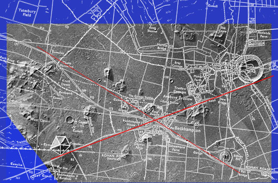
1. The Face on Mars (Viking image 1976) |
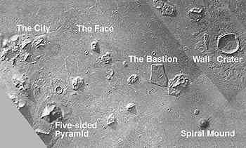
2. The Cydonia Complex, Mars (Viking images 1976) |
This article will demonstrate that there is an apparent connection between the complex where the 'face' is to be found on Cydonia, Mars – located at 41°N latitude – (figures 1. & 2.) and the Avebury complex, just north of Stonehenge, England.
Figure 3. is a close up of the Cydonia crater and the 'wall', the latter some two miles long and remarkably straight. (The 'face' is about a mile long, incidentally). The 'wall' clearly sits on top of the ejecta blanket. In other words, the existence of the wall must post date the laying down of the blanket. On the crater rim there is what appears to be a three-sided or tetrahedral pyramid. South of the crater is a mound (figure 2.), which has an apparent anti-clockwise spiral ascending it with a pyramidal structure on its peak. This spiral mound is a mile in diameter and is approximately 500 feet high.
Due west of this mound is a cluster of what seem to be mainly pyramidal structures, one of which has obviously been damaged. This group is referred to as the 'city'. |
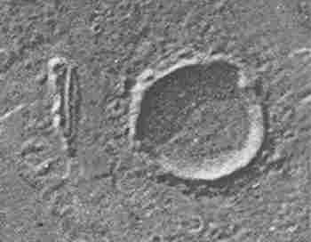
3. The Cydonia Crater and Wall (Viking image 1976)
|

4. The five-sided D&M pyramid (Viking image 1976)

6. Silbury Hill, part of the Avebury complex (north of Stonehenge, England)
|
Located to the south east of the city is a large five-sided pyramid (known as the D&M pyramid, (figure 4). As Erol Torun, a geomorphologist at the American Defense Mapping Agency has stressed, an object with five straight sides cannot be formed, or at any rate cannot be maintained, by the action of wind and weather. For the force that is sharpening one face will at the same time be causing any existing opposite straight sides or edges to erode. Back in 1991 it occurred to me that Avebury circle, (figure 5.) with its earthen rampart and ditch, is a depiction of the Cydonia crater on Mars, suggesting that Silbury Hill (figure 6.) – along with other features in the area – might be an analog model or 'mirror' representation of the key features of Cydonia. 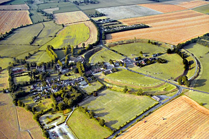
5. Avebury Circle, part of the Avebury complex (north of Stonehenge, England)
|
Working with the large scale UK Ordnance Survey map of the region, I then carefully measured the two sets of items in question and found them to be stunningly proportionate. That is to say, when the Cydonia mound-and-crater complex is reduced by a ratio of approximately 14:1, i.e. fourteen miles in Cydonia equals one mile at Avebury, it fits exactly on Avebury/Silbury (figures 7. & 8.). Avebury circle, for its part, is 'the mightiest in size and grandeur of all stone circles', of a 'magnificent complexity' and measuring a quarter of a mile across. Today a village nestles comfortably within its circumference. One writer comments that if Stonehenge is thought of as a church, then Avebury is a cathedral. Avebury circle consists principally of an outermost earth rampart, with an inner ditch whence the earth for the rampart was dug. About four million cubic feet of material was excavated in order to construct this enclosure. Circles of standing stones then formed further inner rings which were added at a later date. Now let us compare the spiral mound on Mars with Silbury Hill in England. Silbury Hill, I should stress, is not a burial mound, and the entire purpose and significance of the Silbury/Avebury complex remains, at present, a complete mystery. Nine million cubic feet of material was shifted to construct Silbury Hill, the task has been estimated to have taken have taken hundreds of people many years years to accomplish. Interestingly, ancient Britons used to dance up the hill to a maypole on the top – in a spiral. Moreover, it is possible Silbury Hill was constructed as a spiral. 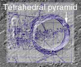
9. Tetrahedral pyramid on the Avebury rampart and Cydonia crater
I had already noted a small mark on the Ordnance map of Avebury rampart (figure 9.) exactly where the tetrahedral pyramid occurs on the crater rim in Cydonia. This mark was located above a gap in the Avebury rampart, just as the Mars pyramid is above a gap in the Cydonia rim. It is the only mound indicated on the Avebury rampart by the Ordnance surveyors and is clearly an analogue of the tetrahedron located in the corresponding spot on Mars. |
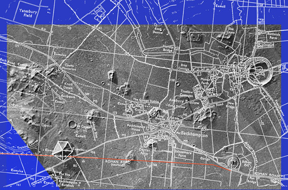
7. Cydonia Complex, Mars with Avebury survey map combined
(the red line is the Roman road)
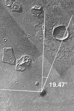 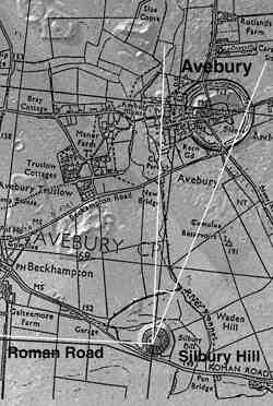
8. Spiral Mound/Silbury Hill and Cydonia crater/Avebury Circle
|
David Myers (of the Mars Mission) and I surveyed the Avebury pyramid on the rim of the rampart in December 1991. This has, obviously, been considerably eroded over a period of nearly 5,000 years, and must once have been a still more impressive feature. The tumulus is indeed tetrahedral in structure but not regular, with two long sides and one short, so that it projects almost lozenge-shaped in one direction. These very same features also appear to be duplicated by the Cydonia rim pyramid.
As William Neil MA an archaeologist has pointed out, the Cydonia crater is a 'Causewayed Enclosure' and Avebury is also a colossal 'Causewayed Enclosure'. Causewayed enclosures predate the stone circles and were in place at Stonehenge and Avebury before the stones were erected.
So the tetrahedral pyramid on the Avebury rampart, north of a gap (a road actually) mirrored by the tetrahedral pyramid on the Cydonia rim, north of a gap (see figure above) – surely sets the final seal of proof, one would like to say the miraculous seal of proof, on a case which was nevertheless already proven without it.
10. The four roads on the Avebury complex form tangents to the structures on Cydonia, Mars |
We must stress again the impossibility, first, of mound plus crater rim in Cydonia and mound plus earth rampart at Avebury having by chance the same relative size, and being the same relative distance from each other. It is also interesting to note in figure 10 (above) that the four roads in the Avebury complex all form tangents with the most significant features of the Cydonia complex – as well as the Avebury landscape. The roads tangent (pass to the side of) the south of the spiral mound/Silbury Hill, to the southern rim of the Cydonia crater/Avebury circle, the south-east corner of the five-sided pyramid and to the north-east corner of the location of the 'city'. It appears that tangents are strongly implied both on Cydonia and in the Avebury analog. And interestingly, the lines cross at the northern tangent of the Beckhampton roundabout (traffic circle).
|
INTELLIGENT PLACEMENT
The following details calculated by archaeocryptographer Carl Munck indicate that the 'face' on Mars was positioned by intelligence (figure 11.).
The angles of a tetrahedron, 720° x 2 = 1440 multiplied by Pi, the universal constant, extends to 4523.893421, thereby encoding 41° 11’ 10.03080581" which is the precise latitude of the 'face' on Mars.
This can be verified by 41 x 11 x 10.03080581 = 4523.893421.
We could deduce from these findings that at some time in the past there has been physical and/or mental communication between Mars and Earth.
NASA went to Mars on behalf of us all to look for life. In responding to the images of certain Cydonia features, is it not it regrettable that the agency appears to ignore, and has attempted to debunk, evidence that strongly indicates the work of intelligent life?
So to conclude, it already seems established beyond reasonable doubt that Mars must once have been inhabited by sentient beings. But even more dauntingly, it is also now absolutely clear that people on Earth 'knew' about that circumstance five thousand years ago, and perhaps even earlier. The second discovery of course reinforces the first.
Or rather, taken together, the two sets of data form a totally unshakeable case. |
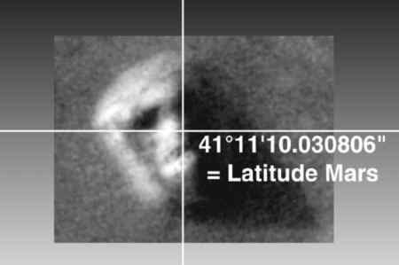
11. The Face on Mars was intelligently positioned – encoding Pi, the universal constant |
Disaster on Mars

|
The Line of Dichotomy two worlds welded together
- or perhaps one world ripped apart -
shaded areas in the southern hemiphere are
between two and five miles higher in elevation
from the lighter areas in the northern hemisphere |
Like the Hopi Indians of North America, the Avestic Aryans of
pre-Islamic Iran
believed that there were three epochs of creation prior to our own. In
the first epoch men were pure and sinless, tall and long lived,
but at its close the Evil One declared war against Ahura Mazda, the
holy god, and a tumultuous cataclysm ensued.
During the second epoch the Evil One was unsuccessful. In the third
good and evil were exactly balanced.
In the fourth epoch (the present age of the world), evil triumphed at
the outset
and has maintained its supremacy ever since.
The end of the fourth epoch is predicted soon, but it is the cataclysm
at the end of the first epoch that interests us here.
It is not a flood, and yet it converges in so many ways with so many
global flood traditions that some connection is strongly suggested.
The Avestic scriptures take us back to a time of paradise on Earth, when
the remote ancestors of the ancient Iranian people
lived in the fabled Airyana Vaejo, the first good and happy creation of
Ahura Mazda that flourished in the first age of the world:
the mythical birthplace and original home of the Aryan race.
In those days the Airyana Vaejo enjoyed a mild and productive climate
with seven months of summer and five months of winter.
Rich in wilflife and in crops, its meadows flowing with streams, this
garden of delights was converted into an uninhabitable wasteland
of ten months winter and only two months summer as a result of the
onslaught of Angra Mainyu, the Evil One.
From: Fingerprints of the Gods - by Graham Hancock |
The Red Menace
As far back as historical records go, even in the most ancient mythologies, we seem to have almost instinctively wondered about the red planet. Before we even knew what a planet was: that little red moving star seemed important, somehow - moreso even than brighter Venus, Jupiter and Saturn; or quirky Mercury.
In the modern era, we have Little Green Men and even Marvin the Martian. From Perceval Lowell's canals, to "The Martian Chronicles" and "The War of the Worlds" the idea of life on Mars has become a part of our pop culture - and now it's a part of our reality.
Moreso than the moon, perhaps mostly because of its habitable possibilities, Mars is in the news. Probes are being sent at every opportunity, manned missions are being planned, even by private entities - and every square meter of "the little world that possibly could" is being thoroughly photographed from above and mapped for future reference. But some of the new images, especially those of The Face, seem doctored - widening the divide, in the interests of the NASA party line: that it's just "a trick of light and shadow" after all.
Less mentioned in the media: the rest of Cydonia, with its many pyramids and other curious anomalies, now coming into sharper view. The angles are still present, the alignments are still precise - their arrangement on the Martain plain still utilizing Sacred Geometry in relation to each other and their precise geographical position on the planet Mars. The Face may have been given a bad profile, but the entire complex is still astoundingly geometric, that must have been intentional.
And there are other anomalous, apparently archaeological, sites on Mars: Elysium Planitia, right on the Martain equator.
|

|
If Cydonia were on Earth, it would be seen as the mother of all monuments
- much older, likely inspiring the architects who designed other impressive
ancient sites, such as Giza, Mexico City and Teohuanaco.
Like a lost Michaelangelo or Van Gogh, found at a neighborhood garage sale,
it's practically a fingerprint; a DNA signature
- or even better, an eyewitness account:
a physical depiction of the former residents
of the ancient, once coastal region of Mars we call Cydonia.
This brings forth, into a more serious light,
new questions as to the origins of Man
and legends of ancient civilizations.
It is easy to get carried away, and wonder:
if our species actually originated on Mars;
or merely colonized this solar system, from somewhere else far out in space;
or if there are other humans civilizations out there, somewhere among the stars.
But, no matter which came first, life on Earth, or life on Mars;
this puzzle-piece of human history can help teach us something about our place in the universe.
Will we dare to ask the improbable questions,
and maybe learn from this, before it's too late
- and possibly save ourselves from a similar fate?
No matter what the original purpose may have been for these structures,
they were built to last.
Were they intended to support a lasting human outpost?
Were they created by ancestors stranded on a dying planet
- desperate for anyone, even their estranged descendants to know the
truth of their existence, or at least where we should begin looking for
it?
Whatever the reason, one effect has triumphed - these gigantic
monuments, averaging a cubic mile apiece, shout to the heavens "we were
here"
- and in the absence of clouds, anyone with a powerful enough telescope
can tell what specific species is represented in indigenous stone.
Even carved out of natural outcroppings, the project was a phenomenal
undertaking by our standards
- so it either meant a very great deal to them, or it was no trouble at
all.
Either scenario is Earth shattering - or in this case, Mars shattering -
literally.
|
Exactly opposite the four largest volcanoes on Mars
(and, indeed, the entire solar system), is Hellas Planitia, (aka: Hellas Impact Basin),
which is actually a giant crater: the largest on Mars (and again, in the entire solar system),
with a diameter of about 1400 Miles (2300 km), about the size of Australia - and four miles deep.
At the bottom, the atmospheric pressure is almost double that of the Martain "sea level"
- making the air just thick enough for liquid water, if the temperature gets above freezing.
This is the deep point of Mars' surface - and if we ever terraform, this is probably where the first lakes will be.
The volume of water it would take to fill Hellas Basin,
if spread evenly over the surface of Mars, would be an eighth of a mile (200 meters) deep.
But the Basin probably never had water in it.
When it was created, something that size, an impact of that magnatude:
if Mars ever had any water (and we have strong evidence supporting that it once did, in abundance),
this is the incident that changed the planet into the frozen desert it is today.
And much of the evidence, in support of water on Mars, has great volumes of it,
rushing across vast plains, carrying boulders with it as it went
- rocks that, themselves, show no sign of water erosion.
The water, literally, disappeared into thin air. |
Mars is thought to have been volcanically dormant for a very long time
(between several hundred million and a few billion years)
- but that dating is based on the amount of impact craters:
supposing, assuming (as is the case today),
such events are relatively very few and far between.
- or date from as far back as the origins of the solar system.
But, if the majority of them happened more or less all at once,
Mars could have much more recently been active, alive and flourishing; even by Earth standards.
The theory goes that in some ancient cataclysm, Mars was hit so hard by a giant meteor:
the intense shockwave created Mars' massive volcanoes, including:
Olympus Mons (with a peak of about 16 miles, or 27km),
the Tharsis Bulge, and upon it, the three Tharsis Montes volcanoes: Arsia, Pavonis and Ascraeus.
(at 9.6, 8.4 and 10.8 miles; or 16, 14 and 18 km elevation, respectively).
Their near precise triangular arrangement matches known impact patterns
- it would be inexplicable, if found to be the result of anything else.
In this event, it is theorized that much of Mars' crust was blasted out into space
(on the opposite side of the planet from impact);
which immediately rained back down on the planet's surface;
In the process, the atmosphere is nearly obliterated;
and with so much less pressure, the ocean quickly evaporates
- the only remnants being at the poles and thinly distributed bits of moisture trapped in the ground as permafrost.
Also possibly created in this catastrophe: Valles Marineris, the largest known rift on a planet's surface:
which dwarfs the Grand Canyon, at 2000 miles (3000 km) long and 350 miles (200 km) wide
- near the Martain equator, dividing the eastern end of the Tharsis Bulge:
which is unique planetwide, for that elkevation,
in that it has no very large impact craters,
indicating a relatively new surface.
- half the planet's surface must have been on fire
Mars' curious, almost total, lack of a magnetic field
lends further credence to the theory of a great and deep, perhaps multiple asteroid impact.
To clinch this theory, scientists would have to determine if it is possible
that most, or even all, ejecta material as evidence of volcanic activity,
could have indeed happened suddenly, and all at once.
Mars' moons, Phobos and Diemos, are but tiny potato shaped chunks of seemingly unrelated matter.
Long thought to be captured asteroids, however unlikely that may seem,
it is now hypothesized that these tiny orbiting lumps of battered charcoal
may be remnants of just such an event.
Or, they may be all that is left of a moon of Mars, that collapsed
- the major portions of which, having fallen in first.

Phobos and Deimos shown together,
for scale
tiny "captured asteroids" at only 17 and 10 miles (27 and 16 km) at widest |
"DARK ZONES" AT THE BOTTOM OF VALLES MARINERIS
ESA scientist: "the data is in too quick to leave time to understand certain mysterious dark spots, sunk in the large canyon of Mars and along certain valleys. They could be sedimentary deposits that the OMEGA instrument of the probe should be able to identify soon."
from: ufologie.net February, 2004
Mars Express: Eos Chasma [high resolution (1.5 MB)] |
|
Residual Water Ice
Vastitas Borealis Crater
photo: ESA/DLR/FU Berlin (G. Neukum)
The HRSC on ESA's Mars Express obtained this perspective view on 2
February 2005 during orbit 1343 with a ground resolution of
approximately 15 metres per pixel.
It shows an unnamed impact crater located on Vastitas Borealis, a broad
plain that covers much of Mars's far northern latitudes, at
approximately 70.5° North and 103° East.
The crater is 35 kilometres wide and has a maximum depth of
approximately 2 kilometres beneath the crater rim. The circular patch of
bright material located at the centre of the crater is residual water
ice.
The colours are very close to natural, but the vertical relief is
exaggerated three times. The view is looking east.
RST Section 19:
Missions to
Mars during the Third Millenium
One surprise Express find:
a standing body of frozen water in a large "pond"
within a crater some 35 km (21 miles) diameter
in the Vastitas Borealis region at a high latitude south of the Northern Ice Cap. |
RST Section 19
Mars Express has also confirmed the presence of water in the South Polar Cap ice.
It has an instrument, Omega, that has a Visible-IR spectrometer.
Below, the right image is a visible color view of part of that Cap;
in the center, the blue pattern demarcates the frozen carbon dioxide; in the left image, the blue indicates a frozen water response.
|
|
Olympus Mons peeking above the clouds
just at the edge of the Martian atmosphere. |
Ancient Martian Riverbed from Mars Global Surveyor
showing only one crater in the riverbed, itself |
 |
Topographical Map of Mars
(click for large version)
Face on Mars FAQ - The Cydonia Anomalies
Frequently Asked Questions
Compiled by Lan Fleming ~ as appearing in "
The Case for the Face: Scientists Examine the Evidence
or Alien Artifacts on Mars" -(Adventures Unlimited, 1998)
from the "Society for Planetary SETI Research" (SPSR) Stanley V. McDaniel and Monica Rix Patterson, Editors
A more thorough presentation, with graphics, can be found at:
» The McDaniel Report and » The Face on Mars Homepage
| Q: | What exactly is this "Face on Mars" and who discovered it? | | A: | The "Face" is a land form that bears a striking resemblance to a human face. It is 2.5 kilometers long, 1 kilometer wide, and 400 meters high. It is located in an area of Mars' northern hemisphere called Cydonia Mensae (Cydonia Plain). It was discovered in 1976 by Viking project scientists in the 72nd photograph taken on the 35th orbit of Viking Orbiter A (Frame 35A72). | |
| Q: | Isn't it true that the human brain is "hard-wired" to see faces in random patterns? | | A: | If this were true, all of us would be forced to "see faces" constantly in random objects as we go about our daily business. Instead, we have the ability to generally distinguish vague, imaginary faces from real ones. | |
| Q: | Aren't those so-called "investigators" actually nothing but believers and zealots who are out to exploit the "Face" for their own profit? | | A: | Members of the Society for Planetary SETI Research (SPSR) are all academically or professionally qualified individuals, many of whom have written and published peer-reviewed papers on this and other scholarly subjects. Their focus of interest is in scientific research. | |
| Q: | Isn't it just plain crazy to imagine that there could be artifacts of an intelligent civilization on the planet Mars? | | A: | Many reputable scientists, including Dr. Carl Sagan and the scientists who authored the prestigious Brookings Institution Report on space policy for NASA in 1960 have proposed that such artifacts might be found on panets in the Solar System. | |
| Q: | If an intelligent race built an enormous "Face" out in the middle of a Martian wasteland, wouldn't there be traces of other intelligent activity? | | A: | There are many unusual features within a 20-mile radius of the "Face" that are under investigation. | |
| Q: | Do the investigators really believe that Martians built a "fortress?" | | A: | No. The commonly used names "Fortress," etc., were originally chosen merely for convenience by science writer Richard C. Hoagland. | |
| Q: | Isn't "image enhancement" just a way to fake photographs? | | A: | See the chapter on "Image Enhancement: What It Is and How It Works" in The Case For The Face: Scientists Examine the Evidence for Alien Artifacts on Mars (Adventures Unlimited, 1998) | |
| Q: | Statistics are used to test predictions about events whose outcomes are unknown before the fact, while the mounds analyzed statistically by Dr. Crater have been there for a long time. How can statistics be relevant here ? | | A: | The angular relationships discovered by Dr. Horace W. Crater were discovered as a result of predictions made on the basis of an initial analysis of four mounds. This is called "a priori" (before the fact) statistical result and is not "a posteriori" (claiming significance after the fact). | |
| Q: | Haven't some investigators chosen some mounds for certain geometric relations while ignoring others ? | | A: | All the 16 mounds in the area have been taken into account. | |
| Q: | On Earth one can see naturally occuring geometric regularities like hexagonal cracks in dried riverbeds, why not natural geometrical formations on Mars ? | | A: | Naturally appearing hexagonal patterns are on a different scale and are not nearly as precise as the patterns of mounds seen in Cydonia. If the mound pattern is natural, it is unlike any natural regularities with which we are familiar. | |
| Q: | Why is it surprising that fractal analysis has shown that the Face and a few of the other so-called anomalies in Cydoinia are different from the surrounding landforms when there is bound to be much variation in the texture of any given natural landscape? | | A: | The fractal technique does not measure mere differences in texture, but the degree of non-fractal response of an object. The more non-fractal the response, the more likely it is that the object is artificial. | |
| Q: | Couldn't erosion explain all the seemingly odd land forms found in Cydonia? | | A: | When an "explanation" is used to explain everything regardless of details, it is no longer an explanation. | |
| Q: | If there are artificial structures in Cydonia, then who built them? | | A: | Assuming the objects are artificial, speculations as to who built them would have to await ground investigation by archaeologists. | |
| Q: | What is NASA's official position regarding Cydonia and the acquisition of new images? | | A: | NASA's official position is that "most scientists" think the Face is an optical illusion. However, we are unaware of any serious scientific study by NASA or others that has either established the natural origin of the Cydonia anomalies or refuted the analyses performed by those who conclude that some of the objects may be artificial. Recently, SPSR representatives met with NASA's Director of Solar System Studies, Dr. Carl Pilcher, on Nov. 24, 1997, and he promised full and regular imaging of Cydonia to the best of Mars Global Surveyor's ability. Dan Goldin, NASA Administrator, also announced new data release policies on Jan. 8,1998 that should stop the initial sequestering of data by NASA contractors and provide the public with very rapid access to NASA acquired data. | |
| Q: | What kind of evidence would it take to convince the Cydonia investigators that they were wrong and that there was nothing there unexplainable in terms of natural forces? | | A: | The hypothesis of possible artificiality could be falsified by new data that produces results contrary to the present data. Failing this, ground investigation by a manned mission could confirm or invalidate the hypothesis of artificiality using standard archaeological methods. | |
| Q: | If the artificiality hypothesis is disproved, wouldn't that mean this has all been a waste of time? | | A: | The methodologies developed by these investigations have wide general applicability to possible future cases requiring the analysis of anomalous objects on the surface of planets. | |
» Ufology - Mars Anomaly Research
» Ufology - Mars Mines Revealed
Related sites:


Please support the UFO Library!
(Kérlek támogasd az Ufológia Könyvtárat!)
YOUR support keeps this site running. Thank you!
(A TE támogatásodra is szükség van!)

|